FAYETTE COUNTY, TEXAS
From Fayette County, Her History and Her People by F. Lotto, 1902
The Bluff Drive |
Opposite La Grange, across the Colorado River and south of Buckner's Creek, begins the Bluff settlement, extending as far as Williams' Creek. The bottomlands of Buckner's Creek and William's Creek, the blackland liveoak sections in the western part of the settlement and the blackland portions of the Navidad Prairie are very fertile. It contains also a great many gravel hills, covered with postoak. Of these latter lands only the better portions are used for fields, the balance remains as pasture land. The Bluff is the most picturesque section of the county; in fact, there is found nowhere in Southern Texas more beautiful scenery. First, there is the road leading up to the Bluff between hills and valleys, nicely graded and graveled. This excellent piece of road work was the first road work done in Fayette county; it was done under Judge A. Haidusek's administration and still remains a model piece of road work. If the traveler, after reaching the summit, takes the first road to the left, it leads him to Kreische's Bluff. From this place the best view of the city of La Grange may be had. Precipitately the bluff falls about two hundred feet. Its foot rests on the river bottom surrounded by trees that vainly try to reach its summit.
On top of the Bluff is the vault that holds the bones of the Dawson men and the Mier prisoners who died for their country in expeditions against Mexico. Here is also the beautiful pavilion of the Bluff shooting club, and the residence of Mr. Kreische, a solid two story brick building. A fine building that at present is not used is the brewery built by Mr. H. L. Kreische, three stories, high, built of rock and picturesquely situated. In earlier times it was a popular resort of the La Grange people and perhaps in time it may be so again. If the traveler descends the sloping sides of the Bluff and walks along its base, he finds huge rocks that have solved themselves from the Bluff and fallen down. To notice their shapes and how they are piled upon each other is quite a pastime. On some of these rocks a little dirt and the seeds of trees have gathered, and good size tree have grown on them, their roots having split the rocks. There are a great many springs on the Bluff with the choicest water.
The Bluff settlement is one of the oldest settlements in the county. It was settled in the thirties and named after the bluff. A great many of the old settlers are Germans who left their country on account of the revolution in Germany of 1848. They were a highly educated, intelligent class of immigrants, friends of liberty and democrats at heart. A superior class of immigrants has never reached the shores of this land from any European country. Among the oldest settlers are the Huebner, Willrich, Richers, Helmcamp, Kreische Otto, Tell, Hausmann, Kraemer, H. Loehr, Wildner and Hinke families. The population is German with a sprinkling of Bohemians and Americans.
Two clubs which own fine halls take care of the social side of life, the Bluff Shooting Club at the Bluff pavilion and the Teutonia Club at Teutonia hall.
Bluff is a voting box of the county and a post office. It has two stores, a blacksmith shop and a gin. The reader will find Mr. Joseph Hausmann, the proprietor of a store, a fine blacksmith shop and a first-class gin, a very accommodating gentleman.
Jesus Maria y Joseph Buena Vista
By Charles Hebert
On March 23, 1690, Alonzo De Leon, the governor of New Spain, Province of Coahuila, left Monclova in northeastern New Spain (now Mexico) to lead the first expedition beyond the Nueces River in search of La Salle’s French Colony. The location was thought to be somewhere on the present-day Texas Coast. It is this expedition that would bring sweeping change to the territory that is now Fayette County, along with the counties that lie to the east across the Trinity River into deep East Texas. Eighty-five armed soldiers; a French-speaking interpreter; two Padres; twelve mule drivers; an unspecified number of Indian guides; over seven hundred horses; two hundred head of cattle and pack mules carrying eighty loads of flour, five hundred pounds of chocolate and three loads of tobacco, the latter to be used for trade with the Indians, accompanied De Leon on his trek northeast.
Traveling about 18 miles per day, the party crossed numerous rivers and streams with De Leon naming them along with every night’s camp in the name of New Spain. The expedition, led by Indian guides, often followed old Indian trails, which were marked with distinctive crosses for expeditions to follow. The expeditions and the participants’ accounts of their encounters with the Indians were filled with fright, as noted by De Leon in his journal. At his first encounter with the Emet and Cava Tribes, however, tribal members immediately fled into the woods for fear of the Spanish, leaving only the dogs behind. Once assured that no harm was intended, the Indians extended to the Spanish a greeting that would become associated with the future name of the state: “Techas, Techas!” This greeting later caught on to be used by various tribes to identify themselves as enemies of the Apaches.
On May 2, 1690, De Leon traversed 91 miles in three days and reached the Rio San Marcos (Colorado River) near present-day La Grange where he noted in his journal that thousands of buffalo were grazing west of the Colorado. De Leon was close to the site of a Toho Indian encampment where he had found two Frenchmen the year before. It was also here that De Leon found two other tribes, the Emet and the Tohaha, encamped near Buena vista, a site which De Leon documented, using an astrolabe.
Following explorations into East Texas in search of Tejas Indians and the remnants of La Salle’s Fort, De Leon began his return trip westward, retracing the same road with the precision that he used on his trip east. On May 11, 1690, the party stopped for the evening at a creek a few miles northeast of the Colorado River, eventually reaching Jesus, Maria y Joseph Buena vista (Jesus, Mary and Joseph Beautiful Vista) on June 17. The identifiable high hill on the Colorado, across from present-day La Grange, would serve as a significant landmark on future expeditions, including Teran’s 1691 Expedition. It has, of course, been a significant landmark throughout the centuries. The site further became a stopping point on the El Camino de los Tejas Road, established during the Spanish Colonial era, from Monclova, New Spain to East Texas and beyond to Louisiana, where it was known as the Opelousas Road.
On July 3, 1691, the area was again revisited by the Spanish, who were led by Captain Martinez with a supply train comprised of twenty soldiers, fifty-six mules and almost three hundred horses to be used as mounts and pack animals to replenish those needed by explorer Captain Salinas. Jesus, Maria, y Joseph Buena vista served as the campsite with Martinez confirming in his journal that he was familiar with the site, having passed it the year before with Deleon.
Numerous expeditions would follow well into the 18th century, led mainly by Catholic Padres spreading Christianity to the Indian tribes of Central and East Texas. All the expeditions followed the same roads explored in the 17th century, following the Indian trails which were crossed again by early Spanish explorers.
The limestone bluff, previously known as Jesus Maria y Joseph Buena vista, and the chalk bluff and lower riffles (Svrcek Riffles), both located upstream from La Grange, all served as reference points for multiple expeditions traveling inland along the river to find the low-water crossing that was first used by bison, then the Indians, followed by La Salle and the Spanish. Due to Indian attacks on several expeditions, part of the old El Camino Real Road that first ran north of Fayette County was re-routed south of the post oak belt, where it crossed the Colorado River at the low-water crossing. It was re-named the La Bahia Road in the late 1700s and was again re-routed to cross the river somewhere between the Hwy 71 bypass and Business Hwy 71 bridge. Later in circa 1838, John Moore’s ferry was located in the general vicinity of the second crossing.
Interestingly, the park with a boat launch below the Business Hwy 71 bridge in La Grange is known as “Buffalo Trails Park” to highlight the fact that bison had once used the low water crossing upstream.
Photo caption:
Looking down from Jesus Maria y Joseph Buena vista (the 200 ft. limestone bluff south of La Grange.); photo courtesy of Charles HebertSources:
Fayette Heritage Museum and Archives
Foster, William. Spanish Expeditions into Texas 1689-1768. First Edition; University of Texas Press, 1995
West, Elizabeth Howard. “English Translation of Spanish Diaries”, Texas State Historical Quarterly, Vol. 8, 1905.
Newcombe, William W. The Indians of Texas from Prehistoric to Modern Times; University of Texas Press, 2002.
Portal to Texas History. www.Texas History.UNT.Edu/ark/67531/meapth/493023
Texas Parks and Wildlife
The Bluff Community
by Carolyn Heinsohn
The community of Bluff was located on the south side of the Colorado River across from La Grange between Buckner’s Creek and Williams Creek. It was named for the high limestone ridge that drops down 200 feet from Monument Hill State Park to the river bottom. This is the most picturesque section of the county with panoramic views of the city of La Grange, the winding river and the beautiful valley below.
The area was settled in the 1830s, although Aylett C. Buckner was already living on the creek that bears his name by the mid-1820s. A great many of the old settlers were Germans who immigrated to Texas during the mid-to-late 1840s, especially after the 1848 revolution in Germany. They were a highly-educated, intelligent group who built fine homes for the era and developed social organizations, shooting clubs and schools. There were also a few Americans of Anglo descent, as well as Moravian and Bohemian immigrants who began arriving in the 1850s. Some of the early families were the Willrichs, Kreisches, Hausmanns, Kraemers, Loehrs, Helmcamps, Huebners, Lauxes, Fietsams, Richters, Hensels, Sladczyks, Jandas, Klimiceks, Hilshers, Lidiaks, Adamciks and Rainoseks.
Indians lived here before the white men took over their ideal habitat, which was well-suited for their native lifestyle. They utilized the large boulders below the bluff and the small caves in the cliffs for shelter. The bluff itself provided a vantage point for viewing the countryside to spot oncoming bison herds. The river not only gave them food and water, but also a means of transportation. The woods were filled with wild game, grapes, persimmons, berries, pecans and various roots, bark and leaves used for medicinal purposes. The clay found along Buckner’s Creek was probably used for making cooking and storage containers. For many years, settlers found a prolific number of artifacts left by these early residents, evidence of their existence in this idyllic setting.
There were also numerous springs, crystal-clear pools and waterfalls tumbling over the rocky ledges. The availability of good water influenced H.L. Kreische, a German stonemason, to build a brewery and his home on the bluff. The topography was perfect for his brewery needs, plus he had an endless source of sandstone rock which was essential for the construction of his three-story brewery that was nestled in a ravine. He took advantage of the downhill slope to collect rainwater in an underground cistern. A limestone kiln that he built was used to provide mortar for the brewery and his three-story home that sat on the very top of the bluff, affording him the best view of the countryside below. The old road and bridges that he built from his brewery down to his ferry across the river on the east side of the bend are still evident under a blanket of leaf mulch that has accumulated for 100 years since the road was last used. Part of the upper road has been cleared by volunteers for a new walking trail within Monument Hill State Park. There is still a clearing from Business 71 south to the river that runs in front of an old stuccoed stone house facing what most likely was Kreische’s ferry road, just east of the present-day Business 71 Bridge.
Kreische’s brewery had a beer hall on the top floor, a popular resort where many local people gathered, usually on Sunday afternoons, dressed in their finest. There was also a pavilion called the Schuetzen Verein (shooting club), which was used for dances, club activities and other entertainment. It was adjacent to the vault that held the remains of the men of the Dawson and Mier expeditions, who were killed in conflict with the Mexicans. The burial vault, monument, brewery ruins and old home have all been incorporated into the state park.
The old Bluff Road that was graded and graveled made its way down through what is now the Frisch Auf Golf Course, first crossing Buckner’s Creek on a wooden bridge built in 1859 and later on an iron bridge built in 1886 to a road that is now Business 71. That road crossed the Colorado River to La Grange over an old wooden bridge built in 1883. It was replaced with a steel bridge in 1899. The winding Bluff Drive and Highway 77 river bridge were not built until 1926. Before the bridges were built, people had to cross the river on ferries. As early as 1839, John Moore operated a ferry that crossed the river at the west end of Lafayette Street, which was known as Ferry Road until the late 1840s.
One of the early German schools in the Bluff community was housed in the Teutonia Hall. The Bluff Public Schoolo was located near the Luckenbach home located on Highway 77 south. Bluff had its own post office for several years in the Engel Store, located about four miles south of La Grange on the old Schulenburg Road, and later a voting box, which was located in the general merchandise store owned by Joseph Hausmann. He also built a two-story home next to the store, as well as a blacksmith shop on the other side, and a gin and grist mill across the road. The old gin was disassembled in 1978, and the ginning equipment was sold to a collector. The old abandoned home, store and blacksmith shop stood next to Hausmann Gin Road for decades, waiting for their demise while resting in the solitude of a small community that died long ago. The property was eventually sold, and the home was re-oriented on the property and restored with a large addition. The store and blacksmith shop were rescued from their impending doom and moved to Marburger Farm, a venue for antique dealers, located between Warrenton and Round Top. Although no longer at their original site, they are now the last remaining vestiges of the old Bluff community, a reminder of times forgotten.
This story was amended in February 2014
The Bluff Schuetzen Verein
by Carolyn Heinsohn
The Bluff Schuetzen Verein, a German shooting club, was organized in the late 1860s by Heinrich L. Kreische, best known as the builder and brewmaster of the Kreische Brewery, which was operated from circa 1860 to 1884. Having been a stonemason before his brewing endeavors, he built a number of homes, stone bridges and commercial buildings in the area, as well as the second courthouse and an early jail.
Kreische built a pavilion on “Kreische’s Bluff” or Monument Hill for the shooting club activities, as well as for other entertainment. He also operated and coordinated the activities at the pavilion, which was located very near the tomb at Monument Hill and only about 200 yards from the Kreische family home. The shooting club paid rent to the Kreisches for the use of the pavilion and the surrounding area for their tournaments. It has been documented that the club paid the Kreische family $25 to $30 rent per month in the early 1900s. After his father’s death in 1882, Henry Louis Kreische continued to operate the pavilion and was more than likely paid by the Verein for his work there as well.
The pavilion was a popular destination for people of the area, who came dressed in their Sunday finery, not only for the shooting tournaments, but for dances, picnics and other celebrations as depicted in various old photographs. In the earlier days, those who came from La Grange had to cross the river with their wagons or carriages on Kreische’s ferry and travel along a road under the bluff alongside the river and wind their way up and around the escarpment to the top of the bluff. The trip, undoubtedly, was arduous, but worth the effort for a weekend outing. The first Travis Street bridge was built across the river in 1883, and then a bridge over Buckner’s Creek was completed in 1886, so the people from La Grange could cross both bridges and travel along the old Bluff Road that was built through what is now the Frisch Auf golf course up to the top of the bluff, which was a considerably easier trip. The members of the Verein were all from the La Grange and rural Bluff area, so attending an event was an all-day affair.
In September 1883, the La Grange Journal described one event: “The Bluff Schuetzen Verein had a big time on the Bluff last Sunday. Music, dancing and target shooting being the amusements engaged in during the day. The Biegel company (military company) passed through town early in the morning, headed by their brass band, and joined the Bluff company (Fayette Light Guard) in the festivities of the day. All who went over report having had a splendid time.” The Fayette Light Guard was an organization of men who participated in competitive military drills. According to a newspaper article in The La Grange Journal in 1888, the group, led by Captain George Willrich, participated in a drill in Austin, at which they were awarded fourth place. Apparently, they also used the pavilion and grounds for their activities.
Each year a “King Shoot”, a traditional German festival that included competitive shooting, was held by the members of the Verein on Pentecost Sunday with shooting commencing at 9:00 a.m. and ending at 12 noon. In the dawn of the morning on the day the King Shoot was to be held, three anvils were loaded with a heavy charge and fired at close intervals. Then the echoes of these anvil shots could be heard from eight to ten miles away from the Bluff. This was done as an awakening to let the people know that another King Shoot was to be held. Another source states that the event was held in late May or early June, so perhaps the dates changed throughout the years.
Shooting was conducted from a bench rest or a large post in the ground notched to rest a rifle on it for a standing position. The targets used at that time were made of wooden boards with 12-13 hand-painted black rings. Three shots were allowed to each member while the person scoring the most rings was crowned King for the year. Then he chose his wife or daughter for his queen. Generally around 4 o’clock in the afternoon, the members of the Verein and a band would march around and into the pavilion where the coronation took place and awards were given to the top riflemen of the day.
The Schuetzen Verein pavilion continued to be an important social center for the people in the area into the early 1900s, and the old crumbling brewery was the site for picnics and a destination for outdoor excursions. The Shooting Club was discontinued in the early 1920s, thus becoming nothing more than a memory and part of the history of the Bluff community. The old Schuetzen Verein pavilion was eventually dismantled, and the wood was acquired by George Adamcik, who used it to build his home nearby. That home is still standing, so in a sense, a part of the history of the Schuetzen Verein is still existing in another form.
Sources:
Appelt, Anton, A. The Life Story of the Kreische Family 1849-1952. Yoakum Herald-Times, Yoakum, Texas; 1967
Fayette County, Texas Heritage, Vol. 1; The Fayette County History Book Committee. Curtis Media, Inc.; 1996
Leffler, John J. The Kreisches and Their World: The Kreische Family, the Bluff Community and Life on “Kreische’s Bluff”, 1840-1960. Texas Parks & Wildlife; Morgan Printing, Austin, Texas; 2008Life in the Bluff Community
by Carolyn Heinsohn
The Bluff area, which has been documented as one of the oldest communities in the county, was first settled by Anglos in the 1830s and was named after the 200-foot bluff on the south side of the Colorado River. It was known as the most picturesque section of the county where the best view of La Grange could be had from Kreische’s Bluff, where Monument Hill State Park is now located. German settlers, who left their country during or soon after the turmoil that resulted in the 1848 revolution, were the next group to settle in the Bluff area. F. Lotto, who wrote an early history book on the county, said that “the Germans who settled in that part of Fayette County were a highly-educated, intelligent class of immigrants, friends of liberty and democrats at heart”.
In the late 19th century, the Bluff area was developing into an identifiable community, although it encompassed a large area from the Colorado River south to Cedar and present-day Hostyn, and southeast to the “Y” at present-day FM 155 and FM 3233. Two of the most historical sites associated with the Bluff community, other than the tomb for the remains of the Dawson and Mier Expeditions, are Kreische’s brewery and his home. The first phase of the brewery was started shortly after Heinrich Kreische’s marriage to Josepha Appelt in 1855 and was mostly completed by the early 1860s. Kreische employed many of his German neighbors, who lived in the area, to help build his brewery and then to help operate it after completion. Kreische also built the Bluff Schuetzen Verein pavilion that was featured in a previous “Footprints of Fayette” article.
There were also several German-Bohemian families in the area who came from the same region in northern Bohemia as Josepha Appelt Kreische, namely the Hausmanns, Leglers, Schroeders and Meiers (Meyers). They were descendants of Germans who had colonized the borderland regions of the Czech Lands from the 13th to the 16th centuries. Anton Legler first worked as a stonemason for Kreische, but eventually moved from the Bluff to Bridge Valley and then to Plum, Texas, where he was the owner of multiple businesses. As a young man, Frank Hausmann, Jr. worked for Kreische as a ferryman, hauling kegs of beer across the river into town to be delivered to various saloons. The Meyers’ property located between the Kreische and Franz Hausmann properties had the Bluff waterfalls and a “swimming hole” that were popular public “hangouts” in the late 19th and early 20th centuries.
A German school, known as the Teutonia School, was built on an acre of land donated by George and Elise Willrich in 1860 to the trustees of the “Latin Settlement” comprised of well-educated and culturally-sophisticated local Germans. In 1873, Bluff’s Teutonia Association was organized by local German-Americans to “promote and cultivate social entertainment, gymnastic exercises and benevolent purposes”. This organization met at the Teutonia schoolhouse, which also became known as “Teutonia Hall”. Eventually, through land sales, the Teutonia School was located on what became Edith Petter’s farm on present-day Petter-Rainosek Loop Road. After the school closed, it was moved to the Louis Eck farm on Creamer Creek Road.
In 1876, a group of early pioneers in the Bluff area, including Otto Ling, Joseph and Franz Hausmann, Henry Loehr, and Messrs. Pescka, Hines and Grasshof, got together for the purpose of establishing a school. Heinrich Kreische donated a large cottonwood tree, and the men took their axes and cut logs to build the school building. The logs were taken to Paul Nordhausen, who owned a sawmill in the Bluff community. He cut all of the lumber free of charge. That same year, land was donated by Mr. Ling near Nabors Creek alongside the old Schulenburg Road, presently Highway 77 South. The Bluff School, a public one-room school, was established with a Mr. Kruse serving as the first teacher. He stayed for two years. Following him were Messrs. Heilig, Dulzer, Hohstetter, Miss Templeton and others. Mr. Hohstetter supposedly was a very tall man, who wore a stovepipe hat and rode a bald-face horse. His description somewhat matched that of Ichabod Crane. [see correction]
In 1886, the people of the Bluff community organized a singing club in order to raise funds to pay for the salary of the teacher. The salaries in those days ranged from $30 to $40 per month for a nine-month term. Families with students attending the school also had to pay $16 per year for the teachers’ salaries. Later an organization known as the “Onward Club” held fundraisers for the upkeep of the little white schoolhouse. A newspaper article mentioned that the attendees at one of their meetings enjoyed interesting talks, songs and musical selections, including violin music by Messrs. Louis and August H. Hausmann and guitar music by Harry Gilliam. Louis Hausmann also gave a presentation about the history of the school at one meeting. Unfortunately, that newspaper article found in a scrapbook did not have a date attached to it.
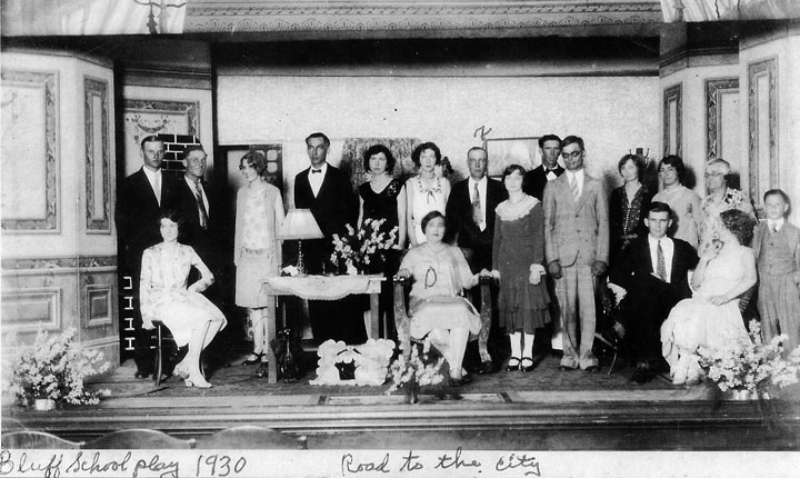
Bluff School Play - 1930
Seated front center: Delta Hausmann; her husband, Frank L. Hausmann, standing behind her on the right; others unknown. (Courtesy - Doris Otto)An old program and a photograph for a play performed by the “Onward Club” in 1930 were kept by Delta Hausmann in a scrapbook, as well as several newspaper articles mentioning various other plays and performances, some of which were presented in other communities throughout the county. The title of the 1930 play was “The Road to the City”. Frank, Gus, Giralda, Delta and Bernice Hausmann all had roles in the play. Two more plays were performed by the club at the La Grange High School Auditorium to large audiences, providing a “neat” sum of money for incidentals for the school. The plays were directed by Miss Edna Legler, the teacher at the time. Hausmann family members were again well represented in the cast, along with members of the Janda, Legler, Lueders and Bock families.
In 1874, Ernst Engel, a German emigrant who arrived in Texas in 1860 and lived and worked as a merchant in High Hill, purchased eight and half acres of land from Henry and Dorothea Berghahn in the Silas Jones league south of La Grange on the old Schulenburg Road in the approximate locale of the Bluff School that was established two years later. The road ran through his land. By 1879, he had built a general merchandise store, which housed a post office named Bluff, Texas. Engel was appointed postmaster and served in that capacity until May 14, 1904, when the post office was discontined and all mail was routed through La Grange. A 1901 postal map corroborates that a post office named Bluff, Texas was located four miles south of La Grange on the Schulenburg Road. The location of the store was in the general vicinity of the Colorado Valley Telephone Co-op on Hwy 77 South adjacent to Petter-Rainosek Loop Road. Engel died on Christmas Eve, 1906; it is not known what happened to his store after his death. Later the Joseph Hausmann, Jr. business complex became known as Bluff, Texas, and the Hausmann Store had the local voting box, although it never housed a post office. So officially, it did not have the state-designated name of Bluff, Texas.
According to James Williams, who helped write a book about an outlaw, William Sherod Robinson, the Engel Store was robbed in 1879 by Robinson, who then was reported seen riding with his gang by the George Willrich home, which was located a short distance south of the Engel Store. Robinson, a former Milam County deputy sheriff who turned to a life of crime in 1879, organized a small gang of outlaws and made himself the leader. He and his men started out rustling horses in the Rockdale area, but then turned to robbing stores in other counties, one of which was the Engel Store at Bluff, Texas. The gang was soon captured, but after getting out of jail on bond, Robinson left Milam County for good, deserting his wife and four young children. He moved to a number of states, adopted the alias of “Ben Wheeler” and eventually was killed by a lynch mob in 1884 after a botched bank robbery in Medicine Lodge, Kansas.

Joseph Hausmann, Jr. Blacksmith Shop - 1898-1900
L. to Rt.: 2nd. - Gottlieb Loehr; 3rd. - Joseph Hausmann, Sr.; 4th. - Joseph Hausmann, Jr.; 5th. - August Herman Hausmann; others unknown. Click on photo for larger image. (Courtesy - Pete Hausmann)Joseph Hausmann, Jr., whose parents purchased land in the Bluff area in 1866, received his limited schooling at the Bluff School, was self-educated beyond that schooling, and was very skilled with his hands, according to his granddaughter, the late Ella Hausmann Barnes, who wrote a story about the family in the Fayette County, Texas Heritage history book. He was given a few acres of land by his father, built a “bachelor house” and then married Dora Loehr in 1882. He began a blacksmithing business in circa 1884. By 1893, he opened a cotton gin across from his blacksmith shop on what is now known as the Hausmann Gin Road. By 1898, he owned and operated a grist mill for grinding corn and a feed mill, both of which were adjacent to his gin. Before 1900, he also built a small store next to his blacksmith shop and a two-story home next to the store. The 1900 census lists Joseph as a merchant, which validates that his store was built prior to that time.
In F. Lotto’s Fayette County – Her History and her People, published in 1902, an ad states that Joseph Hausmann’s Store had general merchandise, groceries, boots, shoes and hardware. It also states that he had a first class gin with all improved appliances, and that his blacksmith work would be done promptly. The late Robert “Buddy” Loehr, a Hausmann descendant, recalled that the Hausmann Store sold “just about everything you needed, including guns, ammunition, dry goods, and cloth….you could buy wine by the glass there – good homemade wine and also corn meal ground at the Hausmann’s stone mill connected to the gin across the road. The store also sold ropes, buggy whips, nails – everything related to a country store.”
The Hausmann Store was enlarged in the early 1930s. Dora, the wife of Joseph, Jr., continued to operate it until 1936 with the help of their daughter-in-law, Olga, who was married to their son, August Herman, who also helped his father in the cotton gin, mill and blacksmith shop, eventually becoming a partner in those businesses. August also drilled water wells and installed Aermotor windmills, pumps, pipes and fittings. August’s son, George, helped his father with the well digging. According to Warren Herzog, August’s grandson, they made all of their own drilling equipment and ran their rig with a 1934 Chevy truck powered by a Model A engine.
After 1936, when his mother, Dora, became too ill to work, August operated the store until his death in 1952. After August died, the store closed, but the gin continued operating until circa late 1950s when cotton was no longer a cash crop in Fayette County. The buildings sat vacant for several decades until the gin was disassembled in 1978, and all of the ginning equipment was sold. The store and blacksmith shop were sold in 2003 by August’s descendants and were moved to the Marburger Farm antiques complex east of Warrenton.
Originally, the Williams Creek Cemetery, located on Kruppa Road, was called the Bluff Cemetery, and the road was the La Grange to Weimar Road. The Bluff Cemetery Association was organized in January 1879. In July of that year, the Association purchased two and 86/100 acres of land from Hugo Lueders in Block 81 of Fayette County School Lands for $50. Lots were assigned by a lottery. In 1912, the Association met in Joseph Hausmann’s store to vote about a name change for the cemetery. Prior to 1900, the word “Bluff” referred to a very large area; however, by 1912, “Bluff” applied only to the Monument Hill area. Since the cemetery was located several miles from Monument Hill, the Association decided that the name should be changed to Williams Creek Cemetery after a nearby creek with that name. There are now over 200 burials in the cemetery.
At one time there was a Nehi bottling plant in a building that is still standing between Hausmann Gin Road and Petter-Rainosek Loop Road. In the 1940s, the RC Bottling Plant in La Grange, which was located next to the Green Lantern Café, purchased the bottling equipment, bottles, etc. from the owners of the plant, who had moved out of the county. After the bottling company was discontinued, the old building was later used as a community center for a number of years. Buddy Loehr remembered playing his violin, mandolin and harmonica at the community center. He also recalled that Joe Kruppa performed there as well. Mr. Kruppa was a “one-man band” who played a bass drum and snare drum with foot pedals and a concertina all at the same time. In the late 1940s, Henry Kruppa, a relative, built and operated a store that was located south of the present-day Colorado Valley Telephone Co-op. The store remained open until the 1970s.
Between the 1860s and 1890s, the population of the Bluff community, which had been predominantly German with a sprinkling of Americans, almost doubled, rising to approximately 700 by 1900, partly due to a new wave of Czech immigration into the area from Moravia. The first Moravians arrived in the Bluff area in 1856 followed by a second group in 1860. After the end of the Civil War, many additional Moravian Czechs gravitated to the area. The Catholic settlers of the Bluff community built their first little log chapel dedicated to the Holy Trinity in 1856 on the John Laux farm approximately three miles east of present-day Hostyn, closer to Kreische’s Bluff. It served the local Catholics until 1869 when a second larger frame church was erected at the site of the present church and renamed Queen of the Holy Rosary, although in the church records, it was usually referred to as the Bluff parish. A Czech Catholic school was built in 1868, and the cemetery was established that same year. According to some sources, Heinrich Kreische helped build both the second and third churches.
In 1888, a much larger and more impressive church was dedicated. That church burned in 1907; it was replaced the following year and served the Catholics in the area until 1966, when the present church was erected. The Kreische family had willed their 344 acres to the Hostyn parish, so in 1952 after the death of Julia Kreische, the family property became the property of the church and the Archdiocese of San Antonio. In 1965, the property was sold to the Frisch Auf Corporation, so the parish razed their old church and built a new one, as well as making other improvements on their property with part of the monies obtained from the sale of the property.
By the late 1880s, the Czechs in the Bluff area had organized their lives and identities around their religion and heritage. A Czech Catholic fraternal insurance organization, known as the KJT (Czech Catholic Union), was founded in Bluff in 1889. The area around their church and meeting hall began to be known as “Moravan”, the name that was adopted by the local leaders for their first KJT Lodge Hall in honor of their Moravian origins. Eventually, a store and saloon were also built in the Moravan area. By that time the Moravan community was developing its own identity and was no longer considered a part of the Bluff community, which probably then extended only as far as the Bluff School and Engel’s Store. After those two places closed, the area that was known as the Bluff community was probably reduced to half its original size. The name “Moravan” was changed to “Hostyn” when Rev. Paul Kasper suggested a name change to the archbishop of the San Antonio Diocese in 1925 to honor a place of pilgrimage in Moravia that is located atop a hill similar to the one at Hostyn.
Although the Czechs and Germans in the Bluff area often conducted their lives in separate circles, they shared places like the Bluff School, Engel Store and Hausmann Store and gin. Eventually, the barriers were bridged between the Germans and Czechs, who connected more and more in the 20th century, even marrying one another, which was a rare occurrence in the 19th century.
There are only a few remaining structures left from the old Bluff community, but according to historical documents, the people who lived there were caring neighbors, who left behind a legacy of community support and involvement. Their lives were intertwined through marriages, work, church and organizations, and some of their descendants still own all or part of the original land purchased by their emigrant ancestors.
Correction: An undated old newspaper clipping about the history of the Bluff School that was used as a source of information for this article had some errors, which have been brought to the author’s attention. According to deed records, Hermann Grasshoff sold approximately 52 acres to Herman “Ernst” Otto in 1875; Otto in turn sold a portion of this land to the Bluff School Association for $1 on March 22, 1883, along with his neighbors, Wendelin and Christiane Peschka, who did the same. So, the name “Otto Ling” more than likely should have been “Ernst Otto”. According to the newspaper article, the Bluff School was founded in 1876. Ella Hausmann Barnes, who wrote about the Bluff School in the Fayette County, Texas Heritage Vol. I history book, also stated that the school was founded in the 1870s. So, the actual date of the founding of the school is questionable, since Ernst Otto and the Peschkas did not sell land to the Bluff School Association until 1883. It is possible, however, that the school was already built, and then later either the involved landowners or the trustees of the Bluff School Association decided that a deed transaction for the school tract was necessary for legal purposes.
Also, a photo in the Fayette Heritage Library and Archives shows the moving of the old Bluff school by Jan Kana to the Louis Eck farm in 1916. Mrs. Barnes also stated in her article that “ nothing remains from the Bluff School, which replaced the original school”. So apparently, the first school was replaced by a new school prior to 1916, and it was the first Bluff School, not the Teutonia School, that was moved to the Louis Eck farm. Also, the size of the Bluff School in the 1916 photo compared to a photo of the Teutonia School confirm that they were different buildings.—C.H.
Sources:
Fayette County Texas Heritage, Vol. 1; stories on Bluff, Hostyn, and Queen of the Holy Rosary Catholic Church in Hostyn, TX.
Fayette County Texas Heritage, Vol. II; family histories for August H. Hausmann by Ella Barnes; Joseph Hausmann, Jr. by Ella Barnes; Curtis Media; 1996.
Gratteri, Len; Cook, Rod; Williams, James. William Sherod Robinson, Alias Ben Wheeler; Eakin Press, 2010
Leffler, John J. The Kreisches and Their World; Morgan Printing, Austin, TX; 2008
Newspaper clippings and paper memorabilia collected by Delta Hausmann, courtesy of Doris Otto, granddaughterTexas' First Brewery
Transcribed by Michael Bates
The following story written by C.E. Lieberman, Vice President & Master Brewer, Gulf Brewing Co., Houston, Texas, was first published in the January 1959 issue of Brewers Digest:
The Kreische Brewery of La Grange, Texas, passed its 100th anniversary in 1955 under a pall of erie unruffled silence. Now stark and lonely ruins, this old beer factory—founded by Henry Ludwig Kreische—is reputed to be the first commercial brewery of the vast sun-drenched State of Texas.
The Kreische home still retains the old-world trappings and dignity. The view of the fuming brewery it once commanded is now completely obliterated with dense, unkempt foliage. This baronial estate has not been vacant many years, as the last maiden daughter clung to the traditional life until finally passing away. She was the last of the strain.
I had the privilege of being escorted through the fascinating brewery ruin by George Adamcik, who knew the Kreische family and who persuaded the last heir to deed the land to the Hostyn Catholic Church. The property is not only closed to the public, but the ruins of the plant are almost inaccessible because of the overgrowth of jungle. The crumbled stone structures of the brewhouse, cellars and lime kiln are in a deep ravine below the sturdy old Kreische homestead.
From the size of the tree trunks, vines and roots that have overwhelmed what used to be a busy industry, this brewery has been idly abiding its time for quite awhile. Still intact are some of the well-laid stone walls.
Stepping into the 40-foot deep vault was a thrill that non-brewers would also experience. At the end of this arched-ceiling cave, the stone fixtures of what used to be the means of receiving the cool spring water are discernable enough to whet the imagination with the difficulties encountered in this type of cellar operation. This unromantic thought would only occur to a brewer, of course.
The roof of the main building above the cellar had collapsed decades ago. Only a few pieces of metal fragments were to be found in the rubble. Where the masonry had escaped the irresistible strength of jungle-growth and pressures from moving earth, it manifests the great pains and skill exercised by the artisans who pioneered this business. Though the vegetation had proved its might, and the twisted trees seem to scoff at mere man through their beards of Spanish moss, it wasn't difficult to picture in ones mind's eye the hustle and bustle that took place around the clearing back in those rustic days.
Strangely, the sight of this old derelict and the stately Kreische home is but a short distance from an imposing monument on top of the hill. In fact, the general location is called "Monument Hill," and over-looks the Colorado River of Texas, and the town of La Grange on the opposite bank. The geographical location might best be described as being between Houston and Austin.
Monument Hill has been designated by the State as a memorial to the 58 Texans whose remains are buried there. During the War with Mexico in the 1830s, these soldiers were captured in the ill-fated Mier raid, led by strong-willed Captain Dawson. The party was captured and taken to Mexico where some were cruelly shot. By wooden wagons their remains were brought to this knoll which is now a state park and commands a picturesque view of the countryside.
Few of the many visitors know that beneath the rambling foliage in the ravine below, a possibly more interesting—though less macabre—relic of these formative days of Texas history lies serenely dormant.
Kreische’s Bluff Beer, Brewed with Pure Mountain Spring Water
by Gregory Walker
Modern residents of La Grange might be embarrassed to call The Bluff a “mountain”, but that was not the case in the 1840s. In those days, this prominent landmark was known as Mount Maria, a name that traced its history back to the earliest Spanish expeditions to the region. The term “mount” or “mountain” was widely used at that time for any height presenting an obstacle to travel. In 1839, George Bonnell stood on the “mount” west of Austin that still bears his name and remarked about the view of “the broken peaks of the mountains rising one above another.” Likewise, many accounts of conflicts between early settlers and Indian raiders along the Colorado River end when the Indians “escaped to the mountains covered with cedar to the west.”
In 1840, Mount Maria was notable not only for its height but also for its flowing spring: “Upon the top of the hill is a spring, the water of which, in its descent, forms a beautiful cascade. At this cascade is found a great abundance of lime stone spar—the most beautiful of all mineral formations.”
In January 1849, Heinrich Kreische bought 172 ¼ acres of land that included the precipitous bluff and the spring on top. For many years, the bluff provided stone for his thriving business as a stonemason. In the early 1860s, he combined his stonework with the abundance of water to create a new business. Where others saw “a beautiful cascade”, Kreische saw a way to harness water and gravity for a large-scale brewery.
Starting at the base of the cascade, or waterfall, Kreische built up from the valley floor. Although no design drawings for the brewery still exist, he must have envisioned the whole of it in detail. At the lowest part of the valley, he created a two-foot drainage tunnel. It was large enough to accommodate the flow from the spring while allowing an air space above the flow. Above this, he built a large vaulted room with three vertical air shafts leading up from the tunnel below. He built a wall across the front of the vaulted room to the sides of the valley. He filled in the space behind this wall to create a floor which was level with the top of the vaulted room. This surface insulated the vaulted room, which was also cooled by an ingenious system built into the structure of the brewery.
The second level was divided into rooms where the main brewing operations took place. On the uphill side of the brewery walls, he built a large cistern to capture water from the spring. The walls of the second level supported the floor of a third level built from wood, which no longer exists. A public beer hall occupied that level.
Kreische did not have steam power to pump water throughout his brewery, so he designed it to let gravity do the work. Water from the spring flowed through two settling tanks and then into the cistern. Several pipes led out of the cistern and into the brewery where the water was used for the brewing operations: soaking the barley to form malt, boiling the malt to create fermentable wort and washing out barrels for re-use.
During the years that the brewery was in operation, the flow from the spring must have been enough to fill and overflow the cistern. This overflow was conveyed by a pipe from the cistern at the top of the brewery down into the two-foot drainage tunnel at its base, revealing the master plan that was in Kreische’s mind before he ever started building. Water flowing through the tunnel cooled the air above it by evaporation. This cooled air was pulled up from the tunnel and into the vaulted fermenting/aging room through the three vertical chimneys. How can cool air flow upward through a chimney? Kreische must have known that wind blowing across the top of a chimney would create a draft that pulled air upward. This cooled air would help keep the temperature of the vaulted room low enough to ferment and age a German-style lager beer.
It would seem that the “great abundance of lime stone spar—the most beautiful of all mineral formations,” which was admired in the 1840s, is now lost to us behind and beneath the Kreische brewery. And yet the processes that formed it out of mineralized ground water can again assert themselves under new conditions. A thin seep of water often flows across the back wall of the vaulted room, and the beam of a small flashlight reveals that the wall is covered by a veil of sparkling crystals. One side wall of the vault is covered by flowing ridges of stone much like the walls of a natural cavern. When standing in this impressive man-made vault, it is still possible to view the beautiful artistry of natural flowstone.
Photo caption:
Schematic drawing of Kreische's Brewery cooling system; courtesy of Texas Parks and Wildlife Department - Archeological AssessmentSources:
“Observations,” Telegraph and Texas Register (Houston, Tex.), Wednesday, May 1, 1839, pages 2-3
“Mount Bonnell”; Handbook of Texas online
Wilbarger, J.W. Indian Depredations in Texas; 2nd edition, page 9.
The Kreische Brewery State Historic Site: An Archeological and Architectural Assessment, compiled by Todd McMakin and James E. Corbin, Texas Parks and Wildlife Department.Kreische’s Quick Lime
By Charles Hebert
Heinrich Kreische arrived in Galveston, along with his brother Carl, on December 27, 1846; together, they began their trek inland towards what is now Mason County. Both men had each been awarded a 400-acre tract of land on the Llano River by the Organization for the Protection of German Immigrants to Texas.
Heinrich soon departed Mason County, leaving behind his land grant, to seek his fortune in Fayette County. Arriving sometime in late 1848, he began to exercise his trade as a stonemason and soon became friends with Georg Carl Willrich, a prominent German settler in the Bluff area. Although Willrich was a lawyer in Germany, he became a wealthy farmer in Fayette County. Kreische soon convinced Willrich to sell him 172 and 1/4 acres on the top of the bluff overlooking La Grange, and it is here where Kreische’s Quick Lime production began.
Lime kilns originated in Europe and were quite useful during the Victorian Era in England (1831-1901) and in part of the Edwardian Era soon after the death of Queen Victoria. It is also probably safe to say that Kreische observed or possibly participated in the construction of such kilns prior to his arrival in Texas, bringing with him this skill along with those of a stonemason.
The 19th century lime kiln on the bluff, constructed by Kreische, is 13 feet square and 13 feet tall with corbelled inner walls to increase the thickness at the top. His lime kiln was a first priority, for without it, the Kreische Home, his brewery, the second Fayette County Jail built in 1853, the third Fayette County Courthouse built in 1855, multiple homes, his beer hall and other business establishments would not have been possible.
So, what exactly is quick lime and how is it made? Quick lime is the calcination of sandstone (calcium carbonate) achieved by burning the stone to a temperature of 1,000 degrees (Celsius) or 1,832 degrees Fahrenheit for a period of three to four days, depending on the quantity of quick lime needed. The process used by Kreische involved lowering a worker via a ladder from the top of the kiln to the bottom. Once inside the kiln, the stacking process began with a layer of wood placed at the base, followed by a layer of stone, with the process being repeated until the height of the interior wood and stone reached about 12 feet with all of the materials being loaded from the top of the kiln. Once the process was completed, the worker exited the kiln at the top, and a fire was started at the base of the kiln to burn the sandstone. Sampling was done by removing some stones from the bottom during the burning process, placing the stones in water to test the liquidity of the sandstone and to assure that the temperature was close to the required 1,000 degrees Celsius or 1,832 degrees Fahrenheit. The process also required the kiln fire to be watched and frequently fanned for 24 hours per day for the duration of the burn. The hazards associated with such work required the workers to wear protective gloves, eyewear and a mask to lessen the danger of carbon monoxide poisoning, burns and the effects of other noxious gases.
The lump lime stone, once cooled, was removed through the opening at the base of the kiln, moved from the area, and was then dissolved with water in a process called slaking. The slaked lime (calcium hydroxide) could then be mixed with sand for mortar or plaster.
Kreische’s kiln ceased operation after his untimely death in 1882. When the Texas Parks and Wildlife Department acquired the property in 1977, the mortar in the kiln was in such good condition that there was no need to do any restoration. Over the years, however, the mortar began to deteriorate, and water began to erode the walls of the kiln.
Wesley King, a professional mason, was consulted to assess the integrity of the kiln. It was determined that at a minimum, the kiln needed repointing, and the capstones needed to be replaced. Starting in late July and working through August 2008, Wesley King, Duncan Grigsby with the TPWD and laborer, Jason Asbill, repointed and repaired the kiln.
The still-standing kiln, his home and brewery ruins all serve as a testament to Kreische’s skill, determination and German work ethic. He definitely contributed to the development of La Grange and the Bluff area by building a number of significant structures during the mid-19th century.
Photo caption: Kreische's limestone kiln near his brewery at Monument Hill State Park; photo courtesy of Charles Hebert
Sources:
“Documentation on How Quick Lime Was Made in Victorian England”. YouTube video
“Lime Kiln”, Wikipedia. The Free Encyclopedia. January 10, 2017. Web Access: March 1, 2017
Texas Parks and Wildlife Docent Manual
Carl Albrecht (1853-1932)
|
Hostyn, Texas
The Latins and the Prairie Blume Society
Monument Hill State Park
Williams Creek Cemetery
Joseph J. Fietsam