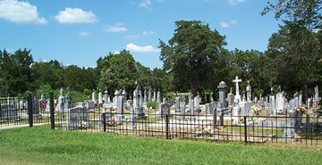
Fayette County Cemeteries
F - G
We are indebted to Kathy Carter, former director of the Fayette Heritage Archives and Museum, for the following cemetery information. Most of these cemeteries were visited by Kathy Carter, Helen Muras and Annette Ruckert in the late 1980s and early 1990s. The Archives staff will check their extensive cemetery database for you by e-mail. All you need is a surname. You do not need to know the name of the cemetery.
All cemetery photos by Rox Ann Johnson unless otherwise noted. If you have a photograph or information about a cemetery you'd like to contribute to this site, please contact Rox Ann.
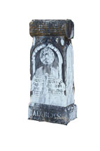
Fahrenthold Family Cemetery
Holman/WeimarOn August 25, 1958 Joe Cole reported: "Farnold Family Cemetery. On the old Vince Petras farm which is owned by Mr. Henry Mazoch at the present time are 7 graves of the Farnold [sic, Fahrenthold] family. I did not learn much of the Farnhold's; only they owned the farm at one time. I was directed to these graves by Mr. Gus Petras who is the son of Vinc Petras. He told me his age was 67 years and that the graves were there before him time." This site is in the vicinity of FM 155 & West Sedan Road, between Holman & Weimar.
The following additional information comes from Sally Fahrenthold: August Fahrenthold married Auguste Emma Fiebig in Fayette County on April 26, 1861. Auguste died on March 2, 1876 and August married Minna Langfeld on May 25, 1880. In a July 13, 1881 Inventory and Appraisement of the Community Estate of August Fahrenthold and his deceased wife, Auguste Fahrenthold, the community property list includes real estate of 58 acres in the Austin League worth $580 and 75 acres in the J. Burnham League worth $225. Both properties were in Fayette County. Personal property includes engine and boiler, cotton press, cotton gin, saw mill and corn mill, 30 cattle, 2 horses, one mule, etc.
On December 28, 1888 August Fahrenthold sold land he had bought from John T. Holman in 1876 and 1880 to Thos. A. Hill. The deed states, "Said August Farenthold hereby reserves the right to fence and care for a space 50 X 50 to include the family graveyard, and to visit the same at his pleasure for twenty years." [in the H. Austin Survey, Vol 34, p 123]Then on January 1, 1891 T. A. Hill sold to Leopold Bordovsky the same parcel of land (96 3/10 acres). The deed concludes "A public school house on the place and the Fahrenthold graveyard is reserved and the right of Fahrenthold to visit said graveyard and keep same in repair for the space of eighteen years is especially retained." [Vol 42, p 72]
August Fahrenthold died in Hallettsville, Lavaca County, on May 23, 1900 and was buried in the city cemetery there. The property had been sold to Frank Cernosek in 1893, again in 1902 to Vincent Petras, then it passed to Gus Petras, then to Henry Mazoch in 1938 and then to Alma Mazoch who owned it in 1973 when a road was widened. Members of the Fahrenthold family have attempted to locate the cemetery in recent years, but have been unsuccessful.
It's likely the following were among those buried in this cemetery:
Fahrenthold, Auguste "Emma" Fiebig, ca 1838 - 2 Mar 1876, daughter of Carl Fiebig
Fahrenthold, Bertha Wilhelmina, 26 Mar 1868-7 Sep 1888, daughter of August Fahrenthold and Emma Fiebig
Fahrenthold infant, son of August Fahrenthold and Emma Fiebig
Fayetteville Brethren Cemetery
Also known as Ross Prairie Czech Moravian Brethren Church, Fayetteville/Ross Prairie
![]() Historic Texas Cemetery designation
Historic Texas Cemetery designation
See an up-to-date list of burials in the Fayetteville Brethren Cemetery.
 Fayetteville Catholic Cemetery
See more photos of this cemetery at TexasEscapes.com.
Fayetteville City Cemetery
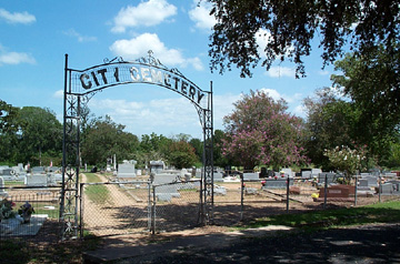
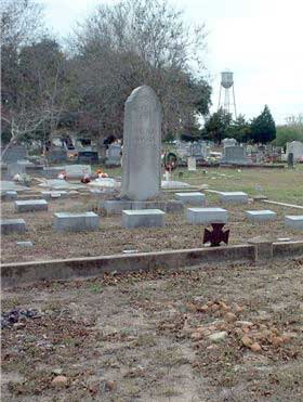
Photo contributed by Lillie Mae Brightwell |
According to Lillie Mae Brightwell, an old map of Fayetteville in the Fayetteville Museum indicates there are some 1812 veterans buried in an old part of the cemetery in the vicinity of the photo below. David Wade and William P. Smith are two War of 1812 veterans buried there.
Notice the two small piles of bricks in the foreground of the photo at left. Many years ago Monroe Johnson of the Johnson Hotel in Fayetteville told Kermit Heinsohn there was a mass burial of veterans after a yellow fever epidemic. Bricks were used to line a large area defining the mass grave. In more recent times, cemetery caretakers thought the bricks were scattered and piled them on two graves. Mr. Heinsohn was unsure whether they were Civil War or 1812 veterans.
Dr. William P. Smith's gravesite also bears a Star and Wreath historical marker that is inscribed:
DR. WILLIAM P. SMITH
A veteran of the Texas War for Independence and regimental surgeon at San Jacinto. Erected by the State of Texas 1962.
Fayette Power Project (FPP) Cemetery Relocation Project
In 1973-1974 the Lower Colorado River Authority of Austin purchased land in Fayette County for the construction of the Fayette Power Project. Several cemeteries were in the boundaries of the project acreage. All the affected burials were disinterred and moved to new sites. Descendants of the deceased were contacted and signed permits were obtained to allow the work to proceed. More than 125 burial sites were involved in the relocation project. The bodies were moved to the New La Grange City Cemetery; Old La Grange City Cemetery; New La Grange Black Cemetery; Fayetteville City Cemetery, New Biegel-December Family Cemetery (on LCRA property); Nordheim Cemetery in De Witt County; and the New Spring Hill Missionary Colored Baptist Church Cemetery.
Joe Cole visited some of the original burial sites during his survey in the late 1950's. They are #115E through #123E in his index. None of the original sites were visited by Kathy Carter and Helen Muras during the Cemetery Survey Project as most of them have been under the water of the cooling pond since the late 1970's. As of 11/1988 no relocated burial sites had been visited with the exception Asa & Green Hill in the Old La Grange City Cemetery and the Helble's in the Fayetteville City Cemetery.
Individual reports were also created for the following cemeteries affected by the relocation project: Biegel-December; Charpentier; Helble; Hill; Kroll; Meitzen; Scherrer; Short; & Spring Hill.
The complete LCRA report of the grave relocation project is available in the Fayette Heritage Archives (BOX C).
From the Footprints of Fayette article by Katie Janda:
One of These Things is Not Like the Other
Actually, several of the gravestones shown in the picture just don’t belong. One day, after spending some time at the New La Grange City Cemetery, I noticed several graves in the newer section of the cemetery that seemed a little out of place. In a section where the burials dated to the 1970s and 1980s, I noticed three older gravestones with death dates of 1870, 1892/1904 (one marker shared by two people), and 1878. It piqued my interest and a quick search indicated these graves (all belonging to members of the Scherrer family) were originally buried at the Scherrer Family Cemetery in Biegel. It made sense right away then, to assume that these graves were relocated from the family cemetery in Biegel to the New City Cemetery in La Grange during the construction of the Fayette Power Plant and Reservoir in the 1970s. This would explain their odd placement in the New City Cemetery.
The history of the cemetery relocation project began around 1973 when the Lower Colorado River Authority (commonly known as the LCRA) purchased land in Fayette County for the construction of the Fayette Power Project. The purpose was to build a clean, coal-burning power plant near La Grange that would provide energy to large parts of central Texas. The project area included the community of Biegel and parts of the community of Park. With its beginnings no later than the 1850s, Biegel initially grew into a small, but vibrant community and it holds an interesting history. The settlement even boasted a pickle factory operated by the Kroll family from possibly the 1860s to about 1916. In about 1887, the railroad came to Fayetteville, bypassing Biegel and causing the community to somewhat decline into more of a quiet, agricultural center with some social activities. By the 1970s, Biegel had become more of a ghost town.
At the time the LCRA began construction in 1974, only three buildings from the town of Biegel remained and they were all moved to different locations – for example, the Bernard Scherrer Home, formerly of Biegel, is now at Henkel Square in Round Top. Although the buildings were removed, many of its former residents were still there, albeit six feet under. There were several cemeteries and individual graves that were identified as being within the boundaries of the project acreage. They could not be left there, as many would undoubtedly be covered by the 2,400 acre cooling pond, now commonly known as Fayette Lake. All descendants of the deceased, if possible, were contacted to sign permits that allowed LCRA to relocate the burials and proceed on the project. Thus, all the burials were disinterred and removed to other burial sites.
The town of Biegel and portions of Park, along with the old resting places of many individuals, are now covered with as much as 70 feet of water in some places. It can be noted that the LCRA and many local historians did a great deal of research to determine the locations of graves, descendants of the deceased, and burial places for relocation. We are grateful for their diligence and hope that the memories of the deceased are not forgotten.
The following is a list of cemeteries and individual graves that were in the boundaries of the LCRA Power Plant Project that had to be relocated. Listed is the original location in parenthesis, the number of graves, and where they were relocated:
- Biegel-December Family Cemetery (four miles NE of Halsted) – 7 graves, all relocated to the New Biegel-December Family Cemetery in Halsted, near original site on LCRA property.
- Charpentier Family Cemetery (1.5 miles NE of Halsted) – 3 graves, all relocated to the Nordheim City Cemetery in DeWitt County, Texas.
- Helble Family Cemetery (five miles E of Halsted) – 3 graves, all allegedly relocated to the Helble family plot in the Fayetteville City Cemetery, although no markers exist for the three. *Joe Cole surveyed this site in 1959 and found seven or eight graves with no markers. However, in 1970, only three graves were identified at the site.
- Hill Family Cemetery (located on Cedar Creek) – 4 graves, two were relocated to the Old La Grange City Cemetery and two (slaves) were relocated to the New Spring Hill Missionary Colored Baptist Church Cemetery in Fayetteville.
- Scherrer Family Cemetery (located at the Biegel Settlement) – 4 persons, 3 graves, relocated to the New La Grange City Cemetery.
- Spring Hill Missionary Baptist Cemetery (1/2 mile west of the New Spring Hill cemetery) – 123 graves, relocated to an entirely new cemetery established for this relocation purpose – the New Spring Hill Missionary Colored Baptist Church Cemetery near Fayetteville on Burnside Road. Of the 123 graves relocated, 70 had markers and 53 did not.
- Kroll Family Cemetery (five miles NE of Halsted) – 4 graves, all relocated to the Kroll family plot in the New La Grange City Cemetery.
- Jennie C. A. Holmgren Meitzen Grave (five miles NE of Halsted) – 1 grave, relocated and buried in the Meitzen plot of the Fayetteville City Cemetery.
- William Short Grave (located at the Biegel Settlement) – 1 grave, allegedly relocated and buried in the New La Grange City Cemetery
- Garett Wormley Grave (was located in the Spring Hill Missionary Baptist Cemetery, ½ mile west of the New Spring Hill cemetery) – 1 grave. This was the only grave from the Spring Hill Missionary Baptist Cemetery to be relocated to the New La Grange Black Cemetery.
- Adolph Weber Grave (near Biegel Settlement) – 1 grave, relocated to the Weber plot in the New La Grange City Cemetery.
Photo Courtesy of Katie Janda: Older Scherrer family graves seen near the back of the photo located in the New La Grange City Cemetery.
Sources:
Fayette County History, Volume I – Fayette Power Project by Gary McKee
Fayette County Footprints Articles from Gary McKee, Sherie Knape
fayettecountyhistory.org
Joe Cole cemetery surveys: 1959
Norman C. Krischke – Biegel Settlement
Fischer-Petschke-Salm Family Cemetery
La Grange
This family cemetery is surrounded by an ornamental iron fence of approximately 30 X 25 feet. It is on the old Carl Fischer Farm. It was owned at one time by Fischer's daughter, Emilie, who married first Albert Petschke and then John Salm. In 1965, Fahnert Schultze owned the property. It is believed that the current (1999) owner is L. J. Hatfield, Sr. The property is located off Airport Road.
Fitzgerald Cemetery
St. John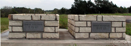
293751N 965935W
The cemetery is open on the south side and has a somewhat sturdy barbed wire and cedar post fence on the other three sides. The west fence measures 62 feet, the north fence is 142 feet long and the east fence measures 67 feet. The rural mail box of Carrie Kutac is at the cemetery.
Samuel Fitzgerald bought the property on which he is buried in 1841. Norman Krischke was told by John Marek that Fitzgerald was a slave holder. Marek said most of Fitzgerald's slaves died within a short period of time and they are buried at the back of Mulberry Cemetery. Samuel Fitzgerald is on the freeholders list in Lotto's Fayette County, Her History and Her People published in 1902. For more information on this cemetery see Norman Krischke's booklet, Fitzgerald Cemetery, written in 1970.
Photo contributed by Phyllis & Charles Sherman
Old Flatonia Cemetery
Old Hallettsville Road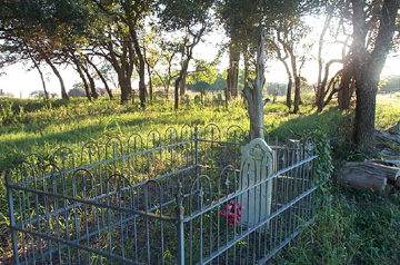
29°39'19"N 97°05'24"W
According to the Joe Cole Cemetery Survey of May 20, 1958 this site is located 2 miles west of Praha and 3 miles south of Flatonia on the Old Hallettsville Road. At one time it covered about 4 acres with graves scattered all over. Mr. Cole first visited the site in 1938 and when he returned 20 years later he states: It was a sad sight to see, There are only three stone left." [Joe Cole #085W] The site was no better off in 1979, when Walter Freytag of the local Historical Commission received a letter from a descendant of Gerhard Siems. Cows had been allowed to graze about the site for years.
On November 18, 1993, Kathy Carter and Fayette County Judge Edward Janecka visited the site with James Wiedemann. Ten stones were found at that time. The Wiedemann, Koch & Siems graves have individual fences around them. The site has several fences running through and across it and cows were still roaming the site.
Norman C. Krischke revisited and surveyed the site in April 2000 and found the Thoms stone, which he dug up from in front of the foundation stone. See his booklet, Old Flatonia Cemetery (Wiedemann Family Cemetery), ©2000 for additional information
See list of burials in this cemetery.
 Flatonia Black Cemetery - Rest Haven
Flatonia Catholic Cemetery
(Sacred Heart Catholic Cemetery)
29°41'36"N 97°06'32"W
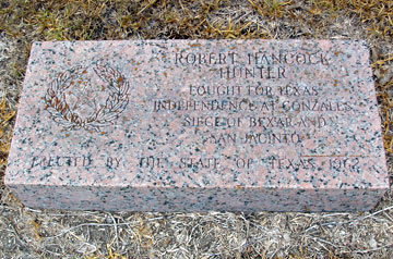
 Flatonia City Cemetery - Oak Hill
Historical marker in cemetery:
Robert Hancock Hunter
Fought for Texas Independence at Gonzales, Siege of Bexar and San Jacinto. Erected by the State of Texas, 1962
Photo contributed by Marion and Steve Daughtry
See photographs of Boehm and Marburger graves at Flatonia's Oak Hill Cemetery.
Florida Chapel Cemetery
Also known as Townsend Cemetery
Between Round Top and Warrenton
See photos of a few of the markers in the Florida Chapel Cemetery.
Louis Franke Grave
Black Jack Springs
Ludewig Carl Ferdinand Francke was born and educated in Germany. he immigrated to Texas in 1845. He fought in the Mexican War and became a Texas Ranger. He married Bernhardine Romberg, daughter of Johannes Romberg, in 1853. They lived on a 100-acre farm near Black Jack Springs with their 10 children. Louis Franke was a Fayette County Commissioner and later was elected to the Texas House of Representatives in 1872.
On Feb. 19, 1873 just after the legislative session ended and he had collected his salary of $260, he was assaulted as he was leaving the old capital building. He broke his thigh when he rolled down the steps. He was taken to a friend's home where he died. His remains were taken to his home at Black Jack Springs off Guettermann - Ehler Road & FM 609] and interred in the family cemetery. A sandstone enclosure 11 feet wide by 14 feet long and three feet high was constructed around the grave in 1875. It was repaired in 1968.
The above information taken from the paper, "Louis Franke," by Gertrude Clara Marie Franke.
Franz Graves
Fayetteville
This cemetery was found and photographed by Bill Simank, 1116 West Knapp, Stillwater, OK 74075 in May 1991. The site is located about 1.5 miles from Fayetteville between FM 1291 and Highway 159, near to County Road 256. It is located on the Alois Keilers farm.
Mr. Simank states: "In the will of my great grandfather, Carl August Simank, he mentions that his beloved wife [Johanna Magdalena Roessler Simank] is buried on his farm. The Fayette County Surveyor located the farm for us. It is part of Mr. Keilers land. It is also located 1.5 miles from Fayetteville on FM 1291. There is a 1.5 acre triangle of land located on the top of the hill back from FM 1291 that we think could have been the burial site. We could find no evidence at all of a grave or graves. This 1.5 acre triangle of land is about 1/8 mile from the [Franz and Rossbach stones]. The 1.5 acre triangle was part of my great grandfather's land. . . ."
The three stones that were found were:Franz, Eduard A., 23 Feb 1804 - 1 July 1864
Franz, Johanne E., 8 August 1820 - 25 Dec 1898, first married Edward Gustas Rossbach and after his death on 23 Sep 1852 she married Eduard A. Franz
Rossbach, Anna, 12 May 1852 - 29 Aug 1867, daughter of Edward Gustas & Johanne Rossbach
More information about these familes can be found in the Franz Family Cemetery file of the Fayette Heritage Archives.
Freiburg Cemetery
![]() Historic Texas Cemetery designation
Historic Texas Cemetery designation
Also known as ODHS (Hermann Sons) Cemetery
See a list of burials and more photos of the Freiburg Cemetery.
Freyburg United Methodist Church Cemetery
FM 2238 at Freyburg
Frick Family Cemetery
Also known as Ray Cemetery
Floy
According to the Joe Cole Survey of January 1958 this public cemetery is one mile west of the Floy schoolhouse on the north side of a dirt road. Jabor Ray and his wife Lena Frick are buried here (no markers found for them). There are also 11 unmarked and unknown graves.
According to Norman Krischke report of May 1, 1973, this site is 5.5 miles southwest of Muldoon on the north side of County Road 154, .2 miles east of County Road 180. It is 55 yards north of the gravel road and is not fenced. Precise coordinates are 29*46"10"N 97*07'29"W. Krischke found 2 marked graves, 15 graves with sandstone markers and 6 areas with lilies growing which may be grave sites.
Brown, Oscar, 2 Jun 1883 - 8 Sep 1889, marble stone
Ray, Jabor, no proof of burial here
Ray, Lena Frick, no proof of burial here, wife of Jabor
Ray, M. E., 10 Sep 1862 - 6 Dec 1890, marble stone
Gay Hill Cemetery
Hwy 71 South, 7.5 miles from La Grange
View diagram and annotated list of grave sites in the Gay Hill Cemetery.
Gay Hill Black Cemetery
 This site is located 7.5 miles south of La Grange on Hiway 71 next to a church. The graves are not laid out in any order. Several vault coverings have sunk into the ground. There are several home-made cement markers where the paint has peeled off.
Gerlach Cemetery
US 290, 4 miles west of Carmine
Located immediately south of US 290 on a small triangle of land lying between Trailer Park Road and a private road, this cemetery is very overgrown and contains no markers. It was listed in a 1906 deed as being one-quarter acre and may be enclosed by an old fence or fragments of an old fence. Gerlach family tradition says there were the following burials:
Gerlach, ??
Gerlach, ??
Koch, ??
Koch, ??
Pruegner, August, died 31 May 1900
Ziegler, ??
German Grave
Colony
The following comes from the booklet, Graves, Graves, Graves, written by Norman C. Krischke, copyrighted 1999:
Indianola, in Calhoun County, was a gateway to the highlands of Fredericksburg in 1846 when Otfried Han Freiherr von Meusebach (John O. Muesebach) led a wagon train of 120 German settlers from the port of Indianola to Fredericksburg and founded that city 8 May 1846. Many wagon trains followed over the years.
Indianola was destroyed by a hurrican in September 1875. Rebuilt, it was finally destroyed forever 20 August 1886.
It is believed that sometime after the Civil War and before September 1875 a lone wagon pulled out of a wagon train headed for Fredericksburg to seek help at the Richers Cabin on Dogwood Branch in southwest Fayette County. A woman aboard the wagon was sick and stopped at the cabin to regain her health.
Richer's cedar cabin was small, about 12' X 16', with a sandstone chimney. The hand-dug well was about 50 feet to the north of the cabin lined with mortated sandstone blocks. A hunter's bull dog fell into the well once and the owner used a length of barbed wire to hook its collar and pull him out. The well presently is circled with a cedar-post barbed wire fence to keep cattle from falling in.
The sick woman got worse and died while camping there at the cabin. She was buried about a hundred feet in front of the cabin and a mortared sandstone vault was constructed over her grave. The vault was enclosed in a wooden grave frame prior to the 1930s. In the early 1920s someone destroyed the vault and dug down into the grave looking for valuables. The grave was not reached in the digging, however the rocks are still scattered; witnessed 9 June 1970. Otto Steinhauser rebuilt the wood frame, but now, all that is left of it is one 4" X 4" corner post. - Courtesy of Otto and Terry Steinhauser
Krischke's full report, a map, and drawings can be found in the cemetery files of the Fayette Heritage Archives.
Gleckler Family Cemetery
Relocated from Bluff
This cemetery was located on the Gleckler [also seen as Gloeckler, Gloeckner, Gleckner] family farm in the Bluff neighborhood. David Gleckler (8 Dec 1820 - 12 Apr 1900) and his wife Elizabeth Gunzler Gleckler (1 May 1814 - 16 Sep 1889) were buried here. At some point, David and Eliza Gleckler were moved to Section 1, Lot 117 of the Old la Grange City Cemetery. Their son Joseph and his wife Josephine are also buried in this lot.
For more information see the cemetery files of the Fayette Heritage Archives.
Gosch Cemetery
Cistern
See an annotated list of grave sites at the Gosch Cemetery and some family background.
Gravel Hill Cemetery
La Grange/Rutersville
A reference to the Gravel Hill cemetery can be found in Joe Cole's cemetery book at the Fayette Heritage Museum & Archives. He wrote that it is a black cemetery and there used to be a church next to it called the Gravel Hill Methodist Church. Names of some people buried there are Grant, Brown, Blackburn and Nuton [Newton].
Gerhard Gerdes owned the property at one time and he is also supposed to be there, which would mean that not only African-Americans are buried there. Unfortunately, stones have been shredded over and pieces are scattered around. There are are no recent surveys of this cemetery. The Gravel Hill Cemetery is on private property just north of Janssen Lane near Anders-Daniels Road.
Gresser Cemetery
Near Fayetteville, Texas
View list of grave sites in the Gresser Cemetery.
J.D. Grove Cemetery
Near Plum
Joe Cole reported on this site in May 1958: "On Colorado River north of Plum. This could be the Plum Grove graveyard of J.D. Grove. If it is, it is the first cemetery west of the Colorado River in Fayette County. T.O. Berry and Dave Berry's wife (Elizabeth Kenner Berry) and others were buried on the bank of the Colorado in 1836. It is told that it was an Indian burial ground before the white man took over." [Joe Cole #037W]
Rosa Berry Cole states in her book, Memories of By-Gone Days, on page 34 "Grandfather T.O. Berry buried in another one near the bank of the river and in fifty years that cemetery was washed in the river in one of those big floods." On page 13: "In November 1834 Aunt Betsy Berry died, leaving an infant son."
Chronicles of Fayette by Julia Lee Sinks pg. 6:
Mrs. Emily Lowd - The J.D. Grove on the Cook League took its name from the circumstance of a man having a barrel of whiskey marked "J.D.," and placing it in the grove to sell, which he did, and dying shortly afterwards unknown to all by name. The grove took its name from this unholy baptism, and by its name keeps alive the memory of one who was in league with death.Mrs. Lucinda Gorham - A man from Bastrop named J.D. Morris lost his way in the grove, and from his difficulties it took its name.

