Indian Creek is an unincorporated community at the intersection of U.S. Highway 77 and Farm Road 153, six miles north of La Grange in north central Fayette County. Its name is derived from the creek that flows through it. A school operated in the community but was later consolidated with the La Grange schools. Indian Creek was the commercial center for farmers of the upper end of the Rabb's Prairie area and provided-in addition to the school-a store, a saloon, a blacksmith shop, and a gin. Declining cotton production during the 1960s forced the gin to close. During the 1980s two businesses remained to serve the needs of the ranching and oil-producing community.
From Fayette County, Texas Heritage, article by Carolyn Heinsohn:
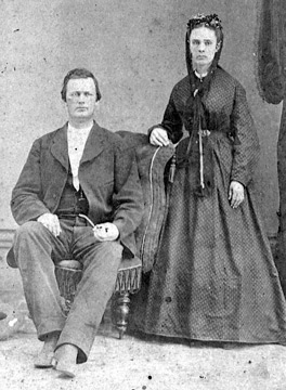
The Indian Creek Community was located about seven miles north of La Grange. A creek by the same name served as the southern boundary line of the community. It was named for the Indians who had settlements in this area, one of which must have been on Mr. Benjamin Buscha's farm based on the numerous arrowheads found there.
A two-room school was built in the early 1900's on the corner of Racetrack Road and county Road 146. One room was the classroom; the other was a cloakroom for coats and lunch buckets. During the winter months, the first student arriving in the morning started the fire in the wood heater. All eight grades were taught by one teacher. There were 22 students enrolled in the 1934-35 school year. From 1935 to 1945, the following teachers taught at the school: Mrs. Hoch, Mrs. Johanna Heise, Mr. Allen Weber and Ms. Gest. The school closed in 1949 when the rural schools were beginning to be consolidated. Mr. Frank Tomacek donated a pump-type merry-go-round for the school playground. After the school closed, it was donated to the Sacred Heart School in La Grange. It is still [1996] being used in their playground.
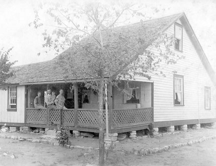
By 1931, Mr. Tomacek built a service station on the corner of what is now Racetrack Road and Hwy 77, when that highway was built through the area. Later he changed the business into a small grocery store. This was the only known business in the community. In later years, the store was owned by the Hobratschk family.
Some of the settlers were the families of the Harbers, Nietsches, Huebels, Drosches, Kratzs, Buschas, Roenschs, Schuberts, Sniders, Vaneks, Michalks, Tomaceks, Schoppas, Michaels, Dreshers, and Seelkes. These were farming families who grew cotton, corn, and milo.
Joiner originated in 1880 in the George Duty League along the banks of the Colorado River approximately seven miles southeast of La Grange. It was established as a result of the Southern Pacific Railroad being built from La Grange to Glidden. Cotton, gravel and wood was shipped from Joiner, which provided for the major source of income for the area's settlers.
The origin of Joiner's name is unknown, although the muster roll for Terry's Rangers, Company F, lists 2nd Corporal B. E. Joiner, age 25, of Fayette county, who enlisted in September, 1861. Perhaps his family were early settlers in this area.
The topography of the area was mostly flat river bottom land with a few scattered trees. Baylor Creek ran through the area on its way to the river. The land was divided into fields and pastures by the early farmers. Only two businesses ever existed in Joiner, a general store and a combination cotton gin and mill, all owned by Albert Nitsche, who built the complex in 1910. His store supplied the sharecroppers with groceries, hardware and other necessities. The cotton gin was operated by a steam engine which also ran the grist mill on Saturdays, when Mr. Nitsche ground cornmeal that was either sold to customers that day or bagged for sale in his store. The cotton bales were shipped to the cotton compress in La Grange.
Besides Mr. Nitsche, other settlers in the Joiner area were the Brugger and Rotter families. There is a lack of information about some of the other early settlers that may have come and gone, because Joiner only existed until the 1930's, a total of less than sixty years. Its decline resulted from the abandoning of the Southern Pacific spur, which not only provided a means of transportation, but also was the main route for cotton to be shipped out of the community. Therefore, the gin was discontinued, and all of the farmers and sharecroppers left the area.
Related article at the Handbook of Texas Online
Joiner, Texas
Footprints of Fayette article by Norman C. Krischke:
Lyons, Texas
DeWitt Clinton Lyons founded the town of Lyons, a mile south of the railroad tracks in Schulenburg, near State Highway 77 in 1842. Comanche Indians five years' prior killed his father, James Lyons, in October of 1837. DeWitt had built a General Store at the crossroads of the stagecoach lines on land originally owned by Kesiah (Cryer) Taylor. Mrs. Taylor had obtained the land from the Mexican Government in April of 1831. Part of Schulenburg was built on Kesiah's league of land. She lived at Lyons for a short time until her third husband, George Taylor, died and then she moved back to Arkansas. [Additional research since this story was originally published, leads us to believe that Kesiah stayed in Texas and was buried in the Navidad Baptist Cemetery.]
The town was first called Lyons Store, then Lyons (Stage) Station, followed by Lyons Post Office, Town of Lyons, Lyonsville and, finally, simply, Lyons. J.G. Armstrong surveyed the townsite about 1845. D.C. Lyons General Store was also the residence of D.C. and Elizabeth (Bridges) Lyons. D.C. and wife moved to near Runge, Texas after the Civil War where they are buried in the Lyons Private Cemetery. DeWitt served nine short terms with the Texas Rangers, including the 1845-1846 war with Mexico.
The town of Lyons had a stage station, post office, doctor, Masonic Lodge, public school, and several general stores. The post office, D.C. Lyons as postmaster, was established in May of 1846 in the Lyons Store and had four boxes in the "lobby". Lyons Lodge No. 195, A.F. & A.M, was founded the 23rd of January 1857 with 21 charter members. Dr. Henry P. Overbay, buried at Old High Cemetery, was the first Worshipful Master and D.C. Lyons was the first Senior Stewart. The lodge building was moved to Schulenburg in 1874, where it was used as the lodge meeting place and as the public school from 1862 to 1900. W. H. Dixon was the first teacher. Lyons Lodge No. 195 is still in existence and located on College Street in Schulenburg.
The Lyons Mounted Riflemen Civil War Company was organized in May of 1861 at Mrs. Bridges' Spring on School Branch. A.J. Murray was Captain of the company of 101 men. William F. Upton was the 1st Lieutenant and W. B. Anderson was 1st Sergeant.
The doctor, who served the community, was Dr. Henry P. Overbay. A.J. Street was the blacksmith, R.H. Skinner operated a carpenter shop and Neill McKinnon had a general store. The town died in 1874 after the founding of Schulenburg in 1873 when the people moved to the new railroad town. The site of the old town of Lyons is marked with a State Historical Marker, erected in 1972.
From Historical Sites and Communities:
Lyons, now just a memory, was one of the towns that packed up and moved to the railroad tacks when Schulenburg was being formed. Sparsely settled from 1831 to 1845, Lyons began to grow rapidly, peaking in 1860, when the local sons marched off to war. The onces that did return found their farms in disarray and squatters living on their land. Lyons was named after a family that was attacked by Comanches and the father killed. The youngest son, Warren, was captured and lived with the Comanche for many years. He eventually returned to his family, but never fully gave up the Indian way of life.
Text from historical marker erected on State Highway 77, one-half mile south of Schulenburg in 1972:
Site of Former Town of Lyons
Early town on land grant of Keziah Cryer. Named for settler James Lyons, killed by 1837 Indian raiders, who kidnapped his son Warren. In 1860s town had stores, Masonic Lodge, school, post office; and was on "Cotton Road" to Mexico, but it died in 1870s when the Southern Pacific Railroad was built.
Abbotts’ Grove School
A Footprints of Fayette article by Carolyn Heinsohn
Lancelot Abbotts, an emigrant from England who achieved considerable prominence in the early days of Texas history, arrived in Texas in January 1835. He first worked as a printer and clerk for the Borden and Baker newspaper in San Felipe and drew the first map of Austin’s Colony. Soon he was in the middle of an uprising by the Texians against Santa Anna and the Mexican government. Abbotts joined the Texas Army, serving from February to September 1836, marching with them to the Battle of San Jacinto, where he served as a rear guard. For his service during the Mexican War, Abbotts was awarded a donation certificate of 640 acres of land in Austin County.
In March 1849, he purchased the Toy League in Fayette County and proceeded to divide the league into numerous parts, conveying it to early settlers as they arrived between the years of 1855 to 1868. In circa 1857, Abbotts built a large three-story sandstone home high on a hill between Hostyn and O’Quinn about a mile south of where FM 609 crosses the O’Quinn branch. He raised sheep and planted a sizeable fruit orchard, which was called Abbotts’ Grove. Abbott returned to England with his wife, Elizabeth, for a temporary visit between the years of 1868 to 1870, leaving his estate to be managed by his cousin, Thomas Carter. However, his wife died in England in late 1870 prior to their planned return a few months later. Abbotts then gifted his land and home to his cousin and never returned to Texas. He married a second time in October 1888, but died a year later in Warwickshire, England.
Thomas Carter eventually sold the majority of the property. There were additions and subtractions made to Abbotts’ home throughout the years by subsequent homeowners, but finally the remaining one-story dwelling fell into ruins.
A part of Abbotts’ land was purchased by Hermann Ahrens in 1890. When the community realized the need for a school, Ahrens allowed the old fruit grove site to be used for a school building; hence the name Abbotts’ Grove School. The school building, which was in Common School District No. 76, was erected in 1893. It was a very small structure – only 18 feet square. In 1901, it was enlarged and extra windows were added, which provided more light for the interior. The grades were separated first by a curtain and later by a moveable wooden partition. The subjects taught were typical of most one-room schools at the time: grammar, composition, spelling, reading, penmanship, arithmetic, history, geography and health.
In the early days of rural education, many of the teachers were single females, and it was customary for them to board with area residents. Many of the teachers at Abbotts’ Grove roomed in the homes of Rudolph Miksch and Paul Jaenichen. Some of the teachers who taught at the school were Tillie Fisher (Stavinoha), Irene Frnka (Meyer), Rosie Jecmenek, Amalia Lueders, Annie Mazoch (Pfertner), Viola Raeke and Dolores Teltschick.
The 1934-1935 school survey done for the Texas Board of Education shows that the school had an enrollment of 41 students with two teachers. Some of the surnames of the students who attended this school were: Dittrich, Foerster, Heinrich, Hengst, Hertel, Kleiber, Knape, Krischke, Miksch, Oeding, Ohnheiser, Roitsch, Stoever and Ulrich.
The school eventually closed in circa 1953 due to the common school districts being consolidated into the larger independent school districts. The school building was sold to John Krhovjak in 1961. Its ultimate demise is unknown. Many of the old schools were either used for some type of farm storage, or they were dismantled so that the wood, doors and windows could be reused in another building. The only remaining evidence of the school is a sign erected by the county that identifies its location on Abbotts’ Grove School Road.
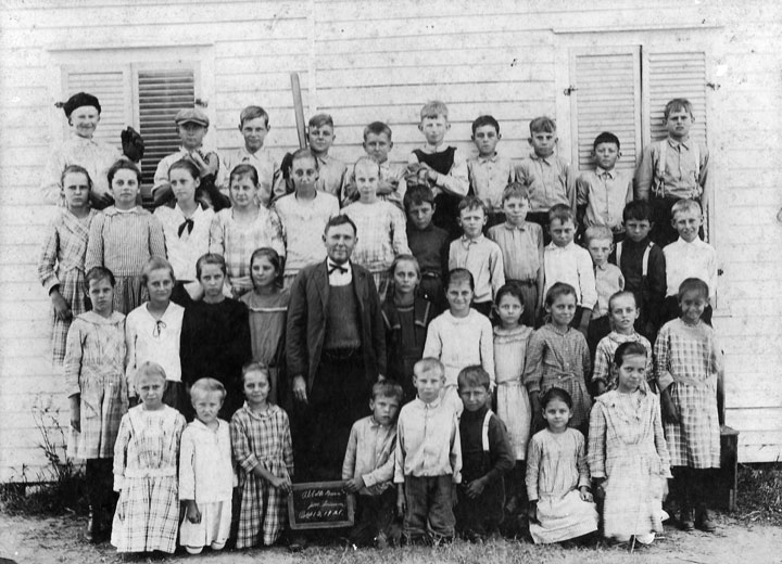
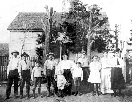
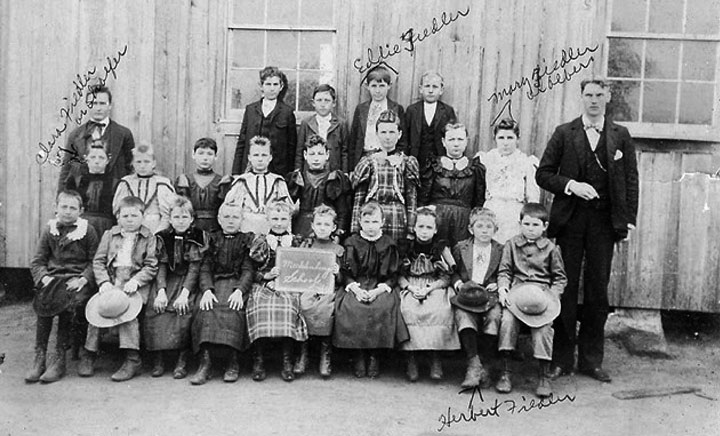
Abbotts' Grove School, 1921
Top row: Werner Bauch, George Stoever, Elmo Roitsch, Ervin Bauch, Oscar Kaase, John Ahrens, Felix Oeding, Albert Hahn
2nd row: Ida Roitsch, Christine Dittrich, Velma Naumann, Adela Foerster, Linda Kaase, Stella Getschmann, Hugo Dieringer, Arthur Getschmann, Paul Stichler, Willie Dietrich, Adolph Roeder, Frank Dieringer, Walter Roeder
3rd row: Hattie Roitsch, Ella Naumann, Frances Niesner, Louise Stoever, J.M. Frierson, teacher, Frieda Hahn, Elsie Schilhab, Elva Oeding, Grace Naumann, Hildagard Nollkamper, Erna Kaase; b
Bottom row: Mathilda Ohnheiser, Pearl Foerster, Wilma Nollkamper, Kermit Roitsch, Rudolph Roeder, Herbert Dieringer, Mae Oeding, Esther Roitsch. Courtesy of J.T. Koenig. Click on photo for larger view.
Sources:
Krischke, Norman C. “Abbotts’ Grove Public School”, Schulenburg; 1993
“Lancelot Abbotts”. Fayette County Archives Staff for “Footprints of Fayette”, September 3,
2001
Related Links
Black Jack Cemetery
Trinity Lutheran Church Baptism & Marriage Records
Cedar O'Quinn School, 1911-1912
Louis Melcher, O'Quinn
The old settlement of Oso is situated about three miles northeast of Flatonia. It used to be quite a town, but nothing has remained of it but the name retained by the neighborhood. After the Southern Pacific passed through the county the town of Oso was deserted and its people settled in Flatonia. Once there were three stores, a mill and a gin, a tannery and a blacksmith shop at Oso. In old times it was a voting precinct, but after Flatonia was built the latter city became the voting precinct of that section of the county. Among the first settlers were the Menefee, Lane, Harrison and Cobb families. The population is American and German.
From Pine Springs Cemetery by Norman C. Krischke, copyrighted 1997:
William Menefee, who signed the Texas Declaration of Independence 2 March 1836, purchased land in the Miguel Muldoon League No. 14 in 1846 and founded the village of Oso on 8 December 1858 with the establishment of a post office. Oso means "bear" in the Indian and Spanish languages. The village was located on present FM 609 about a miles west northwest of the cemetery. Oso consisted of several stores, a gin and grist mill, tannery, blacksmith shop, the Methodist Episcopal Church and school, both of which were located at the cemetery, and a post office. Other family names included Menefee, Lane, Harrison and Cobb.
The neighborhood built a church at Pine Springs called the Pine Springs Methodist Episcopal Church, South. It was located on the east side of the cemetery and on the north side of the walkway to the cemetery. The church burned to the ground on Sunday, 26 September 1880.
The Pine Springs School was established in 1859 and flourished until 1946 when the children of the neighborhood were bused to Flatonia. Myrtle (Bebert) Isensee taught school here a a substitute when the assigned teacher had an appendectomy. Some of the other teachers were: Erna Phillipus, Laura Meyer, Annie Lee Kelly and George Pechacek.
The Shiner Gazette
29 Jun 1898, page 1
A good teacher is wanted for the Oso school, one that can speak the German language. |
|
|
Related Link
See Pine Springs Cemetery
Related article at the Handbook of Texas Online:
Oso, Texas