Communities

FAYETTE COUNTY, TEXAS 

Do you have old community photographs you would like to share?

Park

From The Handbook of Texas Online:
Park is at the southern end of County Road 196 on the northeastern shore of Cedar Creek Reservoir (Lake Fayette) in eastern Fayette County. It was established during the early 1860s and named for the park-like appearance of the oak grove in which it was located. It served as a cultural and trade center for the small farms on the slopes between Baylor and Cedar creeks. Because of the proximity of other trade centers, it never grew beyond a few stores, a dance hall, and a population of fifty, which it still reported in 1940. When the lake was constructed to provide cooling water for the coal-generated Fayette Power Project of the Lower Colorado River Authority, it flooded most of the neighboring farmland and left the grove, one business, and the dance hall on a peninsula. During the 1980s the LCRA and the city of Austin cooperated in building boat-launching facilities and extensive parking areas at the edge of the lake; thousands of fishermen and boaters avail themselves of the facility each year. In 1990 the population of Park was reported as twenty-two.

Pin Oak

From Fayette County, Texas Heritage, Volume I, article by Carolyn Heinsohn:

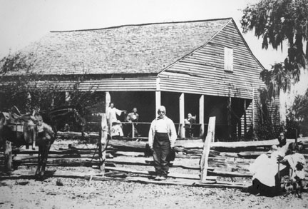
Pin Oak, also known as Black Jack Springs, was located near the La Grange-Flatonia Road between Black Jack and Oso, approximately 12 miles southwest of La Grange. It was one of the early communities of Fayette County, settled predominantly by Americans. In 1840, Leander and Candace Criswell Cottle settled on the headwaters of the West Navidad. some of the early settlers were Obediah Fitzgerald, William Gorham, Haywood Moore, G. W. Tuttle, Thomas Jones, Thomas Speed, Zedekiah Green, Ben, Frank and William Berry, William Arnold, William V. Criswell and his brothers, Leroy, James, John and Joseph. The first school was established in 1840 on the west side of the main road about 0.9 mile south of the road to Muldoon. William Gorham was the first teacher. A second school was built in 1848 on the north side of the present day road to Muldoon about 0.2 mile west of the intersection of FM 609.

In 1846 Black Jack Springs became a voting place, Voting Precinct 7. Leroy Criswell's home was used for voting. The first store was G. W. Tuttle's Store, which also housed the first post office and the justice court; taxes were also assessed and collected in the store. Tuttle was appointed postmaster under the Confederate States in 1861.

J. C. C. Smith established a store and blacksmith shop in 1846; by 1867, he built a new, larger store across the road from his original store. This was the year that the community was partitioned into Black Jack Springs and Pin Oak. Black Jack Springs, was on Thomas O. Berry's League, and Pin Oak, the new name for old Black Jack Springs, was on Noah Karnes' League.

The second post office in the area was located on the west side of the old La Grange - Gonzales Road just south of the present intersection of FM 609 and FM 2237. It was well known as Black Jack Post Office, and Bob Jones was the postmaster.

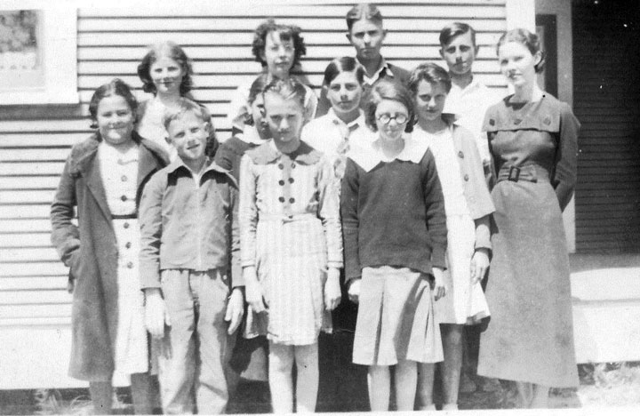
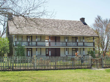
There was still a school in Pin Oak that was operating in 1935, when the enrollment was 35 in grades one through nine. There is nothing left of the community but the Pin Oak (old Black Jack Springs) cemetery, which is one of the oldest graveyards in the county. It is located on private property off of County Road 373. The oldest tombstone is for Lee (Leander) Cottle, buried in 1845.

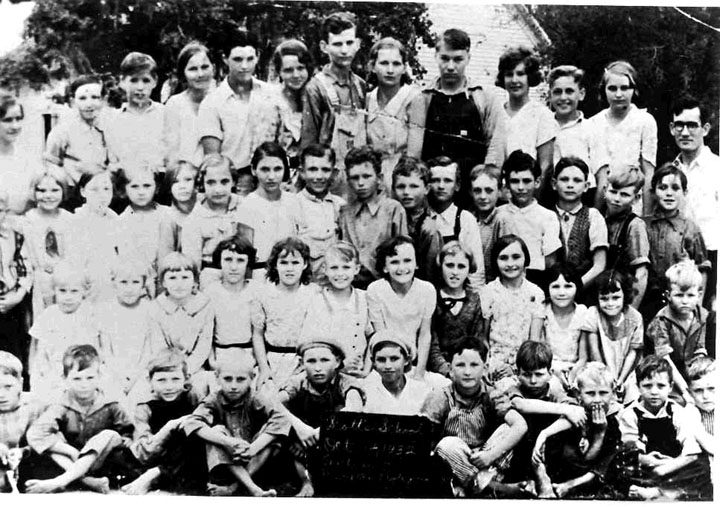
Pin Oak School, ca 1935
The girl in the back row, 2nd from the left, is Mae Eblin Olle. It's believed that one of the other girls' last name was Speed. Can you identify others? Photo contributed by Ronnie Brown.

Pisek

From Fayette County, Texas Heritage, article by Carolyn Heinsohn:

Originally the town of Pisek, which means "sand" in Czech, was located in Colorado County where the present settlement of Lone Oak is today. Before 1900, it had a Post Office, two stores, a blacksmith shop and a dance hall. Some of the early settlers were Henry Dryer, George Erdmann, George Bauer, Franz and Fred Fischer, Andreas Friedrich, Martin Pivonka, Wm. Schoellmann, and the Minssen, Mathias, Geistmann, Brieger, Kickler, Schmidt, Canik, Kulhanek, Dvorak, Stein and Lutonsky families.

The Missouri-Kansas & Texas Railroad completed a line from Dennison, Texas to Boggy Tank in 1887. A railroad turntable was built there. By 1893, the "Katy"Railroad completed another 80 miles of extension from Boggy Tank to Houston.

In 1900, Pisek relocated at the Katy Railroad track, 1/4 mile west from the railroad crossing at Boggy Tank. This site was in Fayette County. Mike Krenek owned a store and cotton seed house, and Lorenz Kulhanek had a saloon in the new town. The Krenek store was later operated by Arno Arndt from 1924 to 1941, when it was relocated at the original site of Pisek on FM 1291. The community was renamed "Lone Oak" for the single oak tree standing in the middle of the road at the present location. What was left of Pisek is now Lone Oak. Therefore, Pisek made a complete circle from the present location of Lone Oak in Colorado County to the railroade site in Fayette County and back again to Lone Oak.

From Historical Sites and Communities:

Pisek, the Czech word for "sand," was located in Colorado county where the present settlement of Lone Oak is today. Before 1900, it had a Post Office, two stores, a blacksmith shop and a dance hall. The town moved [a few miles, into Fayette County] when the railroad was built nearby, but unlike others, retained its name. A minor rail yard was built, with a hotel for the rail employees. When the railroad closed the yard, the town returned to it's previous location but was named Lone Oak.

New Ulm Enterprise, 14 April 2016

100 YEARS AGO —From the April 14, 1916 Enterprise

From Pisek Personals

Pisek is still on the boom. Mike Krenek, one of our enterprising business men, has erected a new building which he will rent out for use as a store. A new blacksmith shop is also among the latest establishments here. Here's wishing continued success.

Plum

See map of Plum and related links.

Praha

See history, photos and other information about Praha.

Prairie Valley

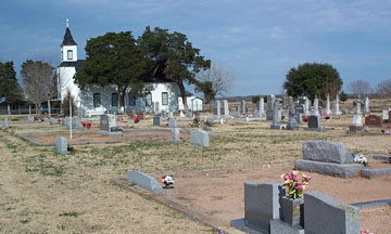
Prairie Valley is located on Prairie Valley Road, just north of Highway 77 between West Point and Plum. This small community settled by Germans once had a school, but now all that remains is St. Peter Lutheran church and its cemetery.

See Prairie Valley Cemetery

Rabb's Prairie

See a brief history of Rabb's Prairie.

Rek Hill

From The Handbook of Texas Online:
Rek (Reks) Hill is on State Highway 159 fourteen miles east of La Grange and four miles northeast of Fayetteville in eastern Fayette County. The community, named for the Reks family who settled in the area, had a church, a school, two businesses, and scattered dwellings in 1940. The school had consolidated with Fayetteville by the 1950s. In 1981 Rek Hill comprised three businesses, a church, and a cemetery.

Rocky Ridge

From Fayette County, Texas Web Site:

Rocky Ridge is located between Muldoon and West Point on FM Road 154. It was named for the rocky terrain of the area.

Ross Prairie

See a history, photographs, and related links for Ross Prairie.

Round Top

See old photographs, historical markers, town map, and a history of Round Top.

Rutersville

See history and related links for Rutersville.

St. John

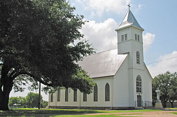
St. John is on Farm Road 957 four miles southwest of Schulenburg at the southern boundary of Fayette County. It had a saloon and store combination and a cotton gin built around the Catholic church which served the local German and Czech farmers. Both the church and the community were dedicated on June 24, 1894, the feast of the Nativity of St. John the Baptist. Cotton farming in St. John stopped during the 1960s, and the gin was dismantled. Mail was delivered from Schulenburg, where St. John children attended school. In 1987 a restaurant, a filling station, a welding shop, and the St. John Church remained to serve an area of farms and ranches devoted primarily to the production of cattle and hay, on gently rolling lands overlooking the West Fork of the Navidad River.

A Footprints of Fayette article by Gary E. McKee:

St. John Schools

St. John, a farming community centered around St. John the Baptist Catholic Church, lies several miles southwest of Schulenburg in Fayette County, Texas. The area was sparsely settled by the Anglos in the mid 1800s, but blossomed with the arrival of Germans and Czechs in the 1870s and 1880s. To educate their youth, a public school was built about 1875. Prior to the establishment of a church, a two story parochial school was built next to the public school on land donated by John Klesel in 1882.  By 1887, four nuns from Shiner were instructing sixty students. It is believed that the schools combined and were taught by nuns.

January of 1888 saw the construction of the church by parishioners. By June, the church was completed and the first baptism was held in October. The school district reported 69 students, but 14 transferred out as their parents pursued work. Over the next several decades the buildings were moved around the property.  In 1917, a public school was built about a mile northwest of the church and was referred to as the Krupala school after the land donors. In 1924, the church closed the school in May. That fall a new priest arrived and began an attempt to reopen the school. After several years, he succeeded, and in the fall a newly constructed two story, two classroom school house was built with a house for the sisters to live on site. The peak enrollment was in 1905 with 160 students taught by three nuns.

In 1933, the Krupala School and the St. John school combined with the Klesel family donating two acres for school activities. Three years later, it was reported that 111 students were being taught by the four nuns. The following year enrollment was up to 118, but in 1938 it had dropped to 97, and it continued to slowly diminish. The hard economic times were causing people to continuously search for work in other areas. A large number of kids had to drop out to continue to help on the farm. Some students remembered that in the fall and spring that school sessions waited until the planting and harvesting of crops were done. The end of World War II saw only 70 students enrolled.

The school offered extracurricular activities in addition to the science, mathematics, geography, spelling and history.  In 1947, there were 4H clubs and a girls’ volleyball team in addition to the Knights of Columbus declamation contest. In 1950, the St. John's girls’ softball team, the “Hightoppers”, defeated Moravia, 18 - 13, as did the boys’ team,  the “Yankees”, 9 - 8.  In 1952, a “Junior American Civics Club” was founded.

In 1959, the 1924 school building was shut down, and the building was moved to St. Rose in Schulenburg. With the school closing, the students spread out to the schools that had bus routes close to their house and attended the Schulenburg, Moravia, Moulton schools and others.

The first school reunion (all students) was held in 1999 with 183 attendees, some of them family of the students. The reunion has been held sporadically since then. The last reunion held on March 16, 2013 drew 35 students and their families. The oldest student attending was Eulalie Kocian Bartos, 89, who attended the 6th and 7th grades in 1941, but she moved away as her father found work elsewhere. The youngest was Carol Berger Sieger, 62, who transferred to Bishop Forest when the school closed. Memories were rekindled as stories were told concerning outhouse pranks, the forbidden cemetery, mudballs, and the choice for young boys between working on the farm or sitting in a classroom – “I need to go home, Papa needs me.  - Why are you home? I'm too sick for school”.

The camaraderie that the attendees expressed demonstrated that the difficulty of growing up on the farm was alleviated by the quality of the education received in the classroom and forged a strong bond among them.

(The author thanks Nancy Pieper and Norman Krischke for their research.)


Related Link

See St. John Catholic Cemetery

Schulenburg

See historical markers, a town map, old photos, and a history of Schulenburg.

Scott Community

From Historical Sites & Communities booklet:

Scott, now a memory, was the only school between Flatonia and Moulton in the 1880s. This community was located just south of Flatonia and was named for a local family who kept many slaves.

Scott's School, 1932
Top Row: Norman Jones (5th from left), Beatrice "Batchie" Jones (6th from left)
2nd Row from the bottom: Julia Zamykal (3rd from left), Eula Mae Jones (5th from left), Bessie Zamykal (9th from left)
Bottom Row: Elmer Dee Jones (6th from left, Hal Jones (10th from left)
Photo provided by Johny W. Jones. Click on photo to see larger view. Do you recognize anyone?

Sedan

From Historical Sites & Communities booklet:

Sedan was located east of Dubina and at one time had a school.

Related Link

Fahrenthold Family Cemetery

Stellar

From Fayette County, Her History and Her People by F. Lotto, 1902:
Stella lies about eight miles southwest of West Point. It is a post office and a voting precinct and consists of one store. The surrounding country is postoak. The population is American.From Historical Sites & Communities booklet:

Stella, now a memory, disappeared when the railroad came to Muldoon. At one time this community had a store, blacksmith shop and gin. 

Related article at the Handbook of Texas Online

Stella, Texas

Swiss Alp

See history and photographs from Swiss Alp

Toledo

Toledo was located north of Black Jack Springs and had a post office from 1873 - 1877 with J. H. Baker as postmaster.

Waldeck

See a full web page of history, photos, links and more about Waldeck.

Walhalla

From Fayette County, Her History and Her People by F. Lotto, 1902:
Walhalla lies fourteen miles in a northerly direction from La Grange. It is situated in Cottonwood prairie, fertile blackland. It is a post-office and a voting precinct of the county, and consists of a store, a saloon and a blacksmith shop. A physician resides there. The population is German. Old settlers: William Koepke, Gerhard Imken, John H. Bluhme, Geo. Oetken, sr., Hon. J. C. Speckels, Hy Alhorn, Chas. Meinhold, Carl Sump, Carl Schubert, Louis Heller, Tom Heller, Dick Meinen and L. F. Tiemann.

From Historical Sites & Communities:

Walhalla is a German community named after a German word for "heaven." Its rise and slow demise was tied to Waldeck. The community is located on FM 1291 about 2 miles north of State Highway 237....

Related Links

See Smalley Cemetery

See photos of Fredrich Schuhmann House (1855) moved to Henkel Square in Round Top.

Related article at the Handbook of Texas Online:

Walhalla, Texas

Warda

See a history of Warda.

Warrenton

See photos, related links and a history of Warrenton.

West Point

From Fayette County, Her History and Her People by F. Lotto, 1902:

West Point lies on the Missouri, Kansas and Texas Railroad and the Waco branch of the San Antonio and Aransas Pass Railway, about twelve miles from La Grange. The section from which West Point draws its main trade is the rich fertile Colorado bottom, deep alluvial soil. The town consists of three stores, one drug store, two physicians, three hotels, two blacksmith shops, two cotton gins, one molasses press owned by Mr. House who turns out a superior molasses known over the county, and one cannery. The latter is owned by a stock company of enterprising citizens and was completed this year at a cost of $6500. The rich surrounding country has various kinds of soil, mostly rich loam beds. It is very favorable to the raising of fruits and vegetables. West Point deserves the credit of starting the industry which (the conditions warrant the belief) promises to become a success. Other sections of the county may follow the example set, quite increasing thereby the income of the farmer and making him independent of the staple article, cotton.

S. A. Shelburne, a native of Austin County, has been for the last nine years in the general merchandise business at West Point and is the leading merchant of that place. F. J. Johnson is the postmaster at West Point, a druggist and a grocer. Mr. Shelburne is a leading democrat and Mr. Johnson a leading republican. O. L. Lee is the proprietor of a first class saloon and keeps the purest and best brands of whiskies. Dr. M. E. Clary is a resident physician of West Point. He has practiced there since 1891, is a fine physician and is regarded as such by the people and by his colleagues.

There are two churches in West Point, a Baptist Church, Rev. W. M. Daniels, pastor, and a Methodist Church, Rev. J. J. Calloway, pastor.

The first settlers in the West Point settlement arrived about the year 1840. The town is located on land that formerly belonged to Bill Young. It is a postoffice since 1872. The population is American with a few Germans among them. Prominent settlers: J. Darby, C. W. Moore, J. L. House, A. W. Young (deceased), T. C. Moore (deceased), W. A. Young (deceased), J. H. Baker, Seth Green, F. J. Johnson and others.

Footprints of Fayette Article reprinted from The Handbook of Texas Online and submitted by Gary McKee:

West Point is north of State Highway 71 twelve miles west of La Grange in western Fayette County. It occupies lands originally granted to Montreville Woods and Thomas Alley in 1831 and was established during the 1880s at the crossing of the Missouri, Kansas and Texas and the Texas and New Orleans railroads. Montreville Woods was of the extended family of Zadock Woods, veteran of the War of 1812 who was later killed in the Dawson massacre. The Woods family established a fort in the area, and the fertile lands south of the Colorado River became known as Woods Prairie. A post office with F. J. Johnson as postmaster was established in 1894, and by 1900 there were four stores, two physicians, three hotels, two blacksmith shops, two cotton gins, a molasses press, and a cannery. John L. House, merchant and owner of the molasses press, succeeded Johnson as postmaster and served in that capacity for thirty years. Highway 71 bypassed West Point one mile to the south, and some of the community moved to the new highway. During the 1940s West Point had a population of 300, eight businesses, and two churches, but children attended school in La Grange. By 1950 the population had declined to 140 and the number of businesses to six. Increased mobility during the 1950s made it possible for people to live in West Point and work elsewhere. During the 1980s the population increased to 204, but the number of businesses decreased to three. The farmland around West Point was devoted primarily to the production of corn and oil and gas from the Austin Chalk formation. In 1990 the population was 205. The population remained the same in 2000.

Luberta (Lula) Johnson Grant
30 May 1875 - 15 Dec 1973
Daughter of James (Jim) and Melinda Powell Johnson
Photo contributed by San K. Marshall
Jerry Grant
born 27 Feb 1872
Son of Warren Grant; married Luberta Johnson
Photo contributed by San K. Marshall
Rufus Grant
Jerry Grant's uncle.
Photo contributed by San K. Marshall

Related Links at Fayette County TXGenWeb Site

Byler Cemetery
Plum Grove Black Cemetery
Plum Grove CemeteryWood's Prairie Cemetery
Mt. Olive African Methodist-Episcopal Cemetery

Related articles at the Handbook of Texas Online

West Point, Texas
Thomas C. Moore
Zadock Woods

Willow Springs

See a history and old photographs of Willow Springs.

Winchester

See a map and history of Winchester.

Winedale

Text from The Handbook of Texas Online:

Winedale was located in far northeastern Fayette County four miles northeast of Round Top. The original community began around 1870 as a German settlement named Truebsal, which grew up just across the line in Washington County near the store of Charles Windewehen. The community eventually included a church and a nearby gin. In 1879, sometime after local farmers began cultivating grapes, a post office was granted with the name Winedale. It closed in 1881, and it is not clear precisely when the town moved some two miles down the road to its location in Fayette County. The new site centered around an inn known as Sam Lewis's Stopping Place on the Sawyer and Risher stage line from Brenham to Austin. Samuel K. Lewis purchased the original 145-acre William Townsend homestead from Capt. John York in 1848, added an adjoining tract of 640 farm acres, and expanded the one-room house to make it suitable for an inn, more than doubling its size and converting the loft into a second story. By the twentieth century the town had ceased to exist. The Lewis home and farm, however, became the centerpiece for the development of the Winedale Historical Center beginning in the 1960s.

Historical Marker

Winedale Stagecoach Inn

From Round Top take FM 1457 W about 2.5 miles then go NW on FM 2714 1/2 miles.

Built by William S. Townsend about 1834. Of cedar timbers– one large room, fireplace and loft for sleeping quarters. Purchased in 1848 by Samuel K. Lewis; enlarged to present form. Became known as "Sam Lewis' stopping place" for many years. Restored by Miss Ima Hogg, 1964. Recorded Texas Historic Landmark, 1967.

Photo contributed by Marion and Steve Daughtry

Related Links

Winedale
A Division of the University of Texas Center for American History

Portraits of Joseph and Maria Wagner, ca. 1880s
Joseph Wagner Family on porch of their home, ca. 1890s
Photo of Joseph George Wagner Family Band, Winedale (Fayette Co.), Texas, ca. 1890.
Wagner House decorative art by Ruldolph Melchior, ca. 1850s
Winedale Photograph Collection, University of Texas Center for American History

Wood's Fort

Text from Historical Marker erected in 1936 at a location 1.5 miles west of West Point on State Highway 71 at its junction with County Road 117:

Site of Wood's Fort

Used by colonists of this vicinity as a protection against Indian attacks. 1828-1842 fortified residence of Zadock Woods, veteran of the War of 1812. One of the old "Three Hundred" of Austin's colonists. Oldest man killed in the "Dawson Massacre" September 18, 1842.

There was also another historical marker at this site, but it was stolen in 1986 according to information in the Fayette Heritage Museum & Archives. Here is the text of that marker:

The First Roadside Park in Texas

Established fall 1933, when a local state highway official built tables and benches (since then replaced ) here to encourage motorists to stop and rest. Texas was one of the first states to sponsor building of roadside parks, which provided work for many of the unemployed during the 1930's depression. Early highway beautification efforts also started here. Today areas along Texas highways are noted for their landscaping and abundance of native wildflowers. Texas roadside parks, many of which have restrooms and cook-out areas, totaled 1,008 in 1967. [1968]

Wood's Fort, 1909

This photo of what remained of Woods Fort in 1909 pictures, from left to right, Middie Darby Moore, James W. Moore, "Uncle Alf" Darby, Lucius Campbell, "Aunt Carrie" Darby holding infant Darby Moore, and Sue Moore.

Alf and Carrie Darby were former slaves of D. A. Darby. The children's parents were Middie and James Moore. Lucius Campbell was James W. Moore's uncle. The saddled horse was named "Charlie." The house burned in 1923.

Photo contributed by Ben E. Kozlovsky, Sr.

Related Link at Fayette County TXGenWeb Site:

Wood's Prairie Cemetery

Zapalac

From The Handbook of Texas Online:

Zapalac was an unincorporated farming community with indefinite boundaries on State Highway 71 between Halstead and Ellinger in eastern Fayette County. It was probably named for Pavel P. Zapalac or other members of his family who resided there in 1884. There was no post office, and the community did not constitute a voting precinct. Residents attended school and church at nearby Joiner, Halstead, Fayetteville, Ross Prairie, or Ellinger.